Rodriguez Pass walking track
Blackheath area in Blue Mountains National Park
Overview
Rodriguez Pass walking track closed
Rodriguez Pass walking track in Blue Mountains National Park is closed due to multiple rockfalls and landslides. It's not safe to hike this track.
Rodriguez Pass walking track in Blue Mountains National Park is closed due to multiple rockfalls and landslides. It's not safe to hike this track. You can access the Grose Valley from Blackheath via Perrys Lookdown.
- Accessibility
- No wheelchair access
- Distance
- 12km loop
- Time suggested
- 4 - 7hrs
- Grade
- Grade 5
- Trip Intention Form
-
It's a good idea to let someone know where you're going. Fill in a trip intention form to send important details about your trip to your emergency contact.
- Personal Locator Beacon
-
If you're planning to loan a Personal Locator Beacon (PLB) from one of these locations, wait and fill out your trip intention form in person.
- Please note
- This long walking track is very steep and difficult, and has minimal signage. It’s recommended for experienced hikers with good fitness and navigation skills.
- Take care as there are exposed cliff edges, steep stairs and slippery creek crossings. Check the weather before you go as creeks can flood after heavy rain.
- Pick up maps and route advice from Blue Mountains Heritage Centre.
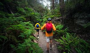
Rodriguez Pass walking track is a must for experienced bushwalkers looking for a heart-pumping day hike in the Blue Mountains. It's a challenging hike from Govetts Leap or Evans lookout, in Blackheath. It winds past spectacular waterfalls, lookouts and lush rainforest in Blue Mountains National Park
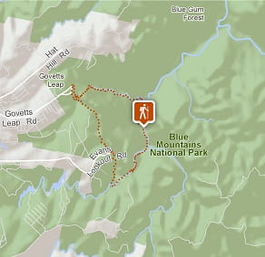
Start at the famous Govetts Leap lookout and descend into the Grose Valley, past hanging swamps, to the base of Bridal Veil Falls. At 180m, it’s the tallest single-drop waterfall in the Blue Mountains.
The walking track winds along Govetts Leap Brook for around 2km, until it meets Govetts Creek at Junction Rock. This is a great place to catch your breath, enjoy a scenic lunch, or take a dip in the creek. You might even spot crayfish. Take a moment to sit back and enjoy the abundant birdlife, including yellow robins, scrub wrens and thornbills, and the beauty of this remote part of the Blue Mountains.
From here, the track turns towards Evans lookout. This section involves some steep climbing, sandstone stairs, creek crossings and scrambling over boulders, before reaching Beauchamp Falls and the Grand Canyon. After climbing the historic stone stairs out of the canyon you’ll be back up on the escarpment to enjoy unforgettable views from Evans lookout.
Loop back to Govetts Leap by taking the 3km Cliff Top walking track. You can also arrange a car shuffle between the 2 lookouts.
Think Before You TREK
Are you planning a bushwalk, going somewhere remote or where the weather is extreme? Stay safe by planning your trip for all conditions and telling someone about it.

Google Street View Trekker
Using Google Street View Trekker, we've captured imagery across a range of NSW national parks and attractions. Get a bird's eye view of these incredible landscapes before setting off on your own adventure.

General enquiries
- National Parks Contact Centre
- 7am to 7pm daily
- 1300 072 757 (13000 PARKS) for the cost of a local call within Australia excluding mobiles
- parks.info@environment.nsw.gov.au
Operated by
- Blue Mountains Heritage Centre and Blackheath office
- 9am to 4pm daily. Closed Christmas Day.
- 02 4787 8877
- bluemountains.heritagecentre@environment.nsw.gov.au
- 270 Govetts Leap Road, Blackheath NSW 2785
Park info
- in the Blackheath area of Blue Mountains National Park in the Sydney and surrounds region
Blackheath area is always open but may have to close at times due to poor weather or fire danger.
What's nearby:
Things to do (129)
- 4WD touring (2)
- Aboriginal culture (6)
- Adventure sports (13)
- Birdwatching and wildlife encounters (11)
- Cafes and kiosks (2)
- Cycling (8)
- Environmental appreciation/study (3)
- Historic heritage (10)
- Other experiences (8)
- Photography (3)
- Picnics and barbecues (13)
- Road trips and car/bus tours (3)
- Sightseeing (69)
- Swimming (2)
- Visitor centres (1)
- Walking (70)
- Waterfalls (42)
- Wildflowers (seasonal) (7)


