Gidjuum Gulganyi Walk: Camping self guided
North Coast
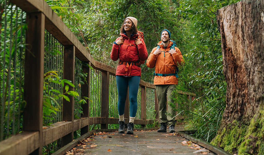
Overview
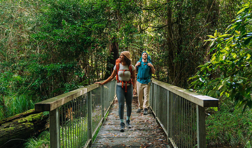
Over 4 days, hike through towering rainforest, clear mountain streams and ancient volcanic landscapes along Gidjuum Gulganyi Walk in the Tweed Byron Hinterland. Camp beneath the forest canopy on hardwood tent platforms.
![]() 4 days 3 nights
4 days 3 nights
![]() 42km Grade 4 - Bushwalking experience recommended
42km Grade 4 - Bushwalking experience recommended
![]() Camp at 3 secluded walk-in campgrounds
Camp at 3 secluded walk-in campgrounds
![]() From $173 per campsite excluding transfers. Each campsite fits 1 to 2 people. Book an optional return transfer with Vision Walks Eco Tours
From $173 per campsite excluding transfers. Each campsite fits 1 to 2 people. Book an optional return transfer with Vision Walks Eco Tours
![]() Available all year, 7 days a week
Available all year, 7 days a week
Manns Road track head to Sand Ridge campground
8.5km
Day 1 begins following undulating paths through tall eucalypt and dense rainforests. You’ll then descend under the green canopy of Whiskey Creek gully with its clear waters. End the day with a final climb to Sand Ridge campground, nestled beneath ancient New England blackbutt trees on a serene ridge top. Settle in for an early night – tomorrow’s track will push your endurance.

Sand Ridge campground to Yelgun Kyoomgun campground
15.5km
Today’s walk is the longest and most challenging, with steep climbs rewarded by stunning views.
Highlights include Grasstree and Tweed Valley lookouts with magnificent views over the Tweed Caldera. See Wollumbin rising in the distance, the dramatic Jerusalem Cliffs, and ancient rainforests. Cross into Nightcap National Park to Doughboy Mountain View lookout and Postman’s Tree. End at Yelgun Kyoomgun camp with a view to the distant lights of Lismore at night.

Yelgun Kyoomgun campground to Weeun Weeun campground
11.5km
Day 3 features forests, wildlife and dramatic views. Spot orange fungi on mossy carpets and red-legged pademelons darting through the undergrowth. Wanganui Gorge lookout offers sweeping vistas of Coopers Creek and cascading waterfalls. End your day at Weeun Weeun camp, surrounded by towering blackbutt trees and perched across from the rainforest-clad slopes of Goonengerry National Park.

Weeun Weeun campground to Minyon Falls lookout
6km
Wake to the sounds of birdlife and begin the day with clifftop views of Wanganui Gorge and Coopers Creek. The trail winds through rainforest, crossing creeks on narrow boardwalks and stepping stones.
As you near Rummery Park the walk takes you past giant lilies, with the calls of frogs echoing in the damp hollows. Your final destination is the spectacular Minyon Falls lookout.
Where you stay
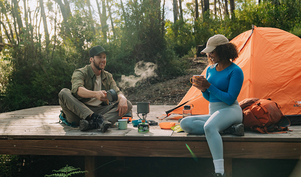
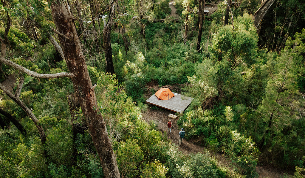
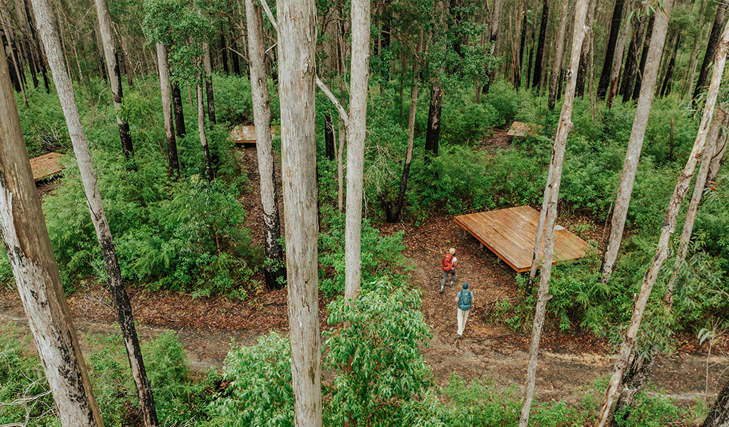
Night 1 | Sand Ridge campground
Camp under a canopy of ancient New England blackbutt eucalypt on the fringe of the rainforest.
Night 2 | Yelgun Kyoomgun campground
This camp is nestled against a slope with towering blackbutts above and a rich understorey of native mint and sedges. Relax to the calming sounds of the stream when it flows after rain.

Night 3 | Weeun Weeun campground
Camp along the escarpment and enjoy magnificent views of Wanganui Gorge from the nearby lookouts.
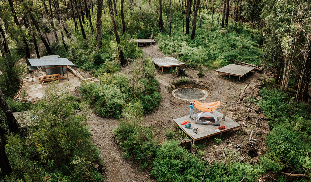
Campground facilities
All 3 campgrounds have:
- Hardwood tent platforms with adjustable chain anchor points to secure the base of your tent.
- Platform size is 4.8 x 3.6m and can fit 1 medium hiker's tent or 2 small hiker's tents.
- Tie down points for guy ropes
- Yarning circles to gather and rest
- Non-flush toilet
- Picnic tables and shelters
- Rainwater tanks. Treat water before drinking.

Detailed itinerary
Day 1: Manns Road track head to Sand Ridge campground
Distance: 8.5km
Time suggested: 2 to 4 hours
Toilets at: Manns Road track head, Sand Ridge campground
Water at: Sand Ridge campground
Your multi-day walk begins today, leading you into a landscape of diverse forests and tracks that will challenge and excite. Stop by Mullumbimby or Uki for last minute supplies before arriving at Manns Road track head – the last spot with reliable phone coverage until the start of day 2.
Ensure you have at least 3L of water per person for today’s walk and pack a reliable method to treat water for the days ahead. Start your walk at the Manns Road track head, following undulating paths through tall eucalypt forest and subtropical rainforest. Notice the striking contrasts in bark textures – from the rugged grooves of ironbark to the smooth, mottled grey of coachwoods.
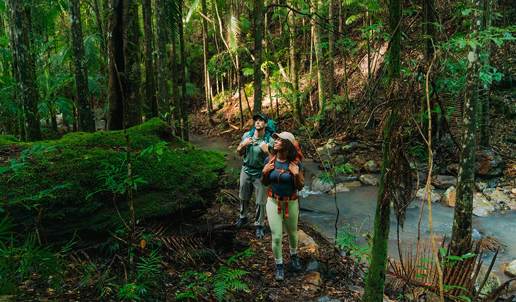
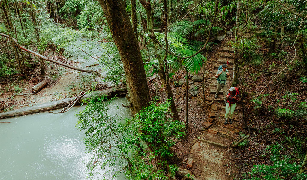
Soon after you set out, a 3km return side track offers a chance to visit Unicorn Falls, a peaceful spot where moss-covered rocks frame a quaint waterfall. Continuing along the main track, the ridgeline leads to Whiskey Creek walk. Descending into the lush gully of Whisky Creek, you’ll be greeted by the refreshing sight of clear running waters with a vibrant green canopy overhead. This section includes 7 creek crossings – be mindful of slippery rocks and changing water levels after rain.
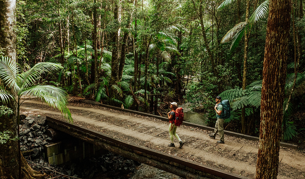
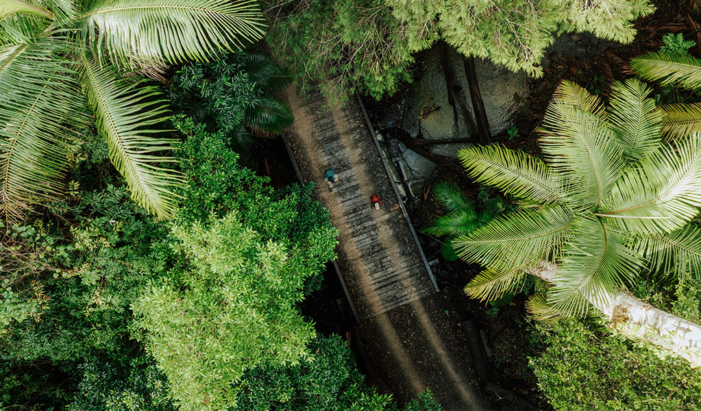
Take a moment at one of the creek crossings for a quiet morning tea and watch for the splash of an eastern water dragon. Continue on through eucalypt forest and subtropical rainforest and listen for the calls of the forest’s rare birdlife, including regent bowerbirds, paradise riflebirds and green catbirds. Crossing the creek a final time, you’ll follow an old logging track as it winds through towering palms and giant strangler figs on a gradual climb to the top of Middle Ridge. A little further on you'll descend off the ridge and eventually cross Sand Ridge bridge. A few hundred metres on, the track diverts off the management trail and leads you through creek lines framed by riparian rainforest.
The final ascent brings you to Sand Ridge campground, perched on a lower saddle of the ridge. Here, beneath the canopy of ancient New England blackbutt eucalypt forest, you can rest and reflect on your journey. An early night is recommended – tomorrow’s track will push your endurance with steep climbs but you’ll be rewarded with spectacular views.
Day 2: Sand Ridge campground to Yelgun Kyoomgun campground
Distance: 15.5km
Time suggested: 7 to 9 hours
Toilets at: Sand Ridge campground, Yelgun Kyoomgun campground
Water at: Sand Ridge campground, Yelgun Kyoomgun campground
Today’s walk is the longest and most challenging, offering sweeping views and a journey through eucalypt woodland and both warm temperate and subtropical rainforest. Prepare for uphill sections, numerous steps and 2 particularly steep sections that will test your stamina. Make sure you check your water supply before setting out, there are no refill points until Yelgun Kyoomgun campground.
Set out from Sand Ridge campground as early as possible, heading past the sheltered picnic table to the marked track at the southern end of the campsite. The walk begins with a steady 2hr climb through eucalypt forest and subtropical rainforest. Along the way, Grasstree lookout rewards you with magnificent views over the Tweed Caldera, with Wollumbin rising in the distance. The path you follow traces the ancient routes of Widjabul Wia-bal ancestors, who walked these lands many years ago while travelling through Country.
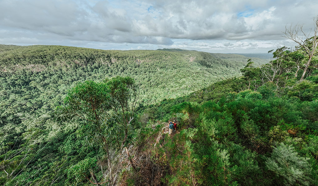
As the track winds south of Mount Jerusalem, the rainforest transitions into warm temperate rainforest before opening into eucalypt woodland. Look for lace monitors basking on sunlit tree trunks or moving stealthily through the undergrowth. Be cautious of slippery conditions after rain, particularly on the old Jerusalem Mountain Road. Soon you will arrive at Tweed Valley lookout, where views stretch across Commissioners Creek Valley. Back on the main track, you’ll descend into warm temperate rainforest. A 500m side track (one-way) offers a steep scramble to Jerusalem Cliffs, where dramatic views over Doon Doon await. From this rocky vantage point, look out for Doughboy Mountain and the Pinnacle in Border Ranges National Park. If you’re lucky, you might catch sight of a goshawk or other birds of prey soaring overhead.
Crossing the Doon Doon saddle marks your departure from Mount Jerusalem National Park. This section of the track passes through a private property easement, so please respect the landholders by staying on the marked track and avoiding unnecessary stops.
Soon after crossing into Nightcap National Park you will encounter Byron View lookout. On a clear day you can spot Byron Headland through a miraculous gap between surrounding landforms. The landscape here feels ancient and otherworldly, with dense rainforest and towering trees. Listen for the ‘chip chip’ call of the threatened rufous scrub-bird and watch for flashes of colour from fruit-eating rainforest doves.
The final climb takes you past Doughboy Mountain View lookout, with a spectacular vista to the north over Mount Tarrawyra. After a short walk, you will reach Tea Tree lookout, where fragrant tea tree scrub lines the Historic Nightcap track. To the south of the lookout, you’ll spot Postman’s Tree, a towering burnt-out New England blackbutt that once provided shelter for travelling postmen.
Day 2 comes to an end through temperate rainforest as you approach Yelgun Kyoomgun campground. Yelgun Kyoomgun (yell-gun key-oom-gun) means ‘sun and stars’ to reflect the view from the campground. The camp is nestled in an understorey rich with native mint and Lepidosperma clipeicola, a rare clumping sedge that only occurs in moist eucalypt forests at higher altitudes associated with the Mount Warning shield volcano. If you’re here during spring, vibrant yellow guinea flowers and blue flax lilies will be in bloom, adding bursts of colour to the landscape.
As night falls, watch for mountain brushtail possums and yellow-bellied gliders emerging in the treetops. Unwind as you take in the distant lights of Lismore twinkling far below – a magical close to an unforgettable day on the track.
Day 3: Yelgun Kyoomgun campground to Weeun Weeun campground
Distance: 11.5km
Time suggested: 3 to 5 hours
Toilets at: Yelgun Kyoomgun campground, Weeun Weeun campground
Water at: Yelgun Kyoomgun campground, Weeun Weeun campground
Your walk today will start and end with striking views. As you set out, the route descends along a ridgeline of the Nightcap Range. You’ll journey through landscapes that shift between rainforest and eucalypt forest. Look for bursts of orange fungi peeking through mossy carpets along the forest floor. In the cooler months, the elusive Albert’s lyrebird may be seen scratching through the leaf litter in search of food. The track weaves through shaded rainforest, following the gentle, soft paths of long-dormant logging roads.
You will cross Peates Mountain Road and link up to Perlite Road and Fork Fire Road before reaching the Eastern Fire Break. Midway along Fork Fire Road look out for the cascades which lead you off the track to a secluded creek, perfect for a cool down. Keep an eye on trail markers to stay on track, and take care crossing roads, as management vehicles may be present. Along the way, you might spot red-legged pademelons darting through the undergrowth.
As you approach Weeun Weeun campground, the landscape opens dramatically at Wanganui Gorge lookout. Sweeping views stretch across Coopers Creek and into Goonengerry National Park, framed by cascading waterfalls tumbling through cliffs and trees. Arriving at Weeun Weeun campground, you’ll find yourself perched on the edge of Wanganui Gorge overlooking Goonengerry National Park. Weeun Weeun (wee-ahn wee-ahn) means ‘home of the cleverman’ in the language of the local Widjabul Wia-bal People.
The lookouts within the campground precinct offer unique perspectives of the Wanganui Valley, where dense rainforest clings to steep slopes featuring waterfalls. As you savour the view, take care to stay well back from the lookout barrier.
At night, go spotlighting to find vulnerable animals like the yellow-bellied glider and marbled frogmouth. Set your torch to a red light to avoid damaging their eyes. Settle in for your final night on the track beneath the towering blackbutt trees. Let the calls of cockatoos and eucalyptus-scented air set the tone for reflection on the incredible journey so far. Rest up – tomorrow’s grand finale at Minyon Falls awaits.
Day 4: Weeun Weeun campground to Minyon Falls lookout
Distance: 6km
Time suggested: 2 to 3 hours
Toilets at: Weeun Weeun campground, Minyon Falls lookout
Water at: Weeun Weeun campground, Minyon Falls lookout
Day 4 begins with a clifftop path offering sweeping views of Wanganui Gorge and Coopers Creek. The track winds through rainforest and eucalypt forest, crossing creeks on the way to your final destination at Minyon Falls lookout.
The track takes you across creek crossings and wet areas on narrow boardwalks and stepping stones, surrounded by lush subtropical rainforest.
Filtered glimpses of the distant coast and Snows Gully Nature Reserve peek through the trees. Take extra care here, wet conditions can make the track slippery and the crossing can become impassable after or during heavy rainfall.
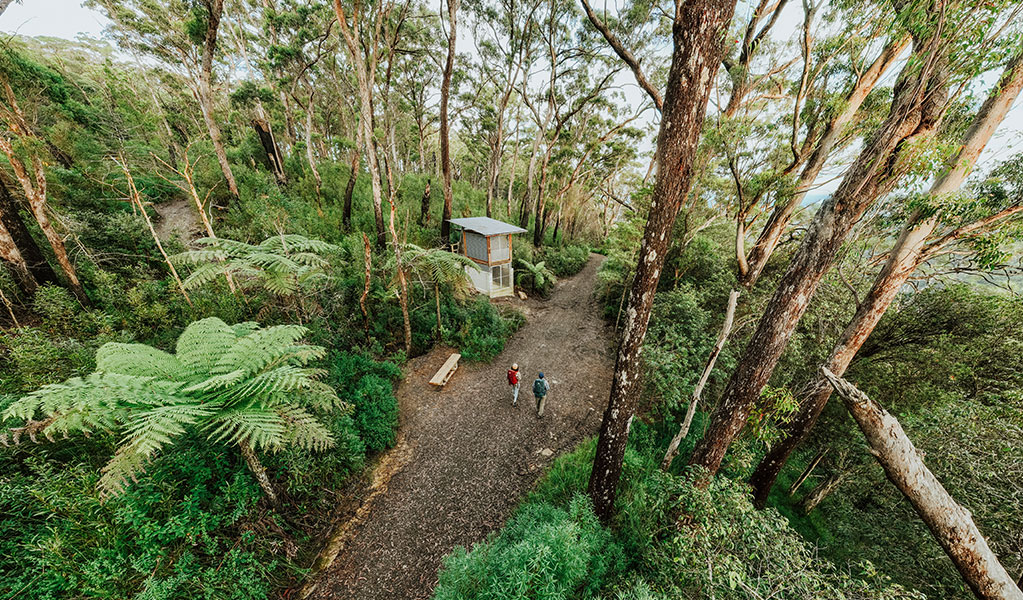
As you approach Rummery Park campground, you’ll discover a rustic timber walkway Tread carefully on the beams. Arriving at the campground, you’ll be greeted by resting kookaburras perched among the tall Hoop pines.
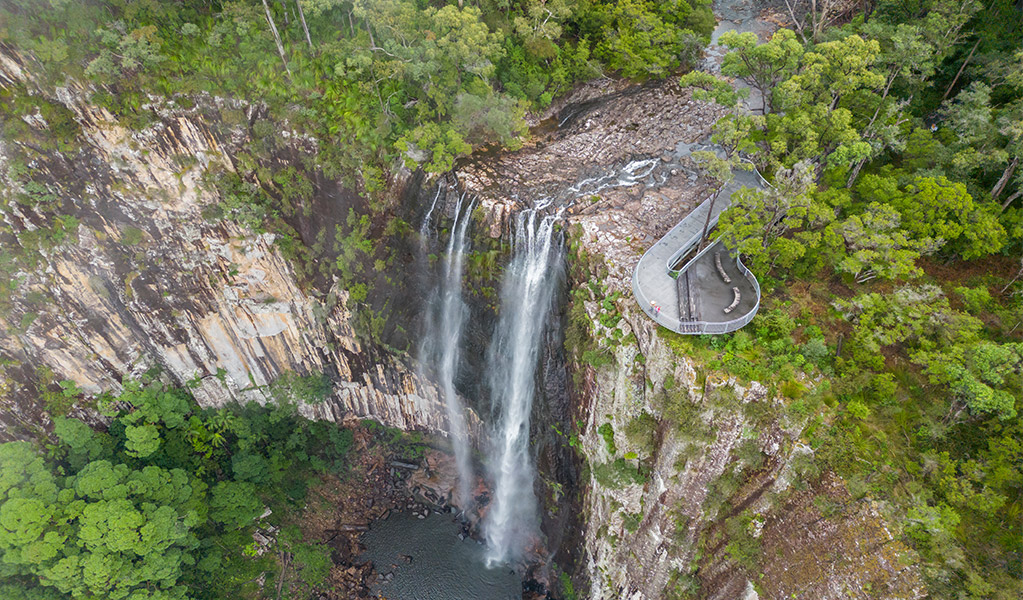
From here, follow Boggy Creek walk for about 45mins, tracing the clear waters of the creek. The track winds through gullies framed by towering blackbutt and turpentine trees, with short, steep climbs leading to tranquil resting spots beside the creek. As you near Minyon Falls, the crashing roar of the waterfall will guide you to the spectacular lookout. From the lookout platform, pause to take in the view of the deep palm-shaded gorge roughly 100m below – a fitting end to your 4-day adventure. On a clear day, the view stretches all the way to the coast.
If you’re still eager to explore, several short walking tracks await in the Minyon Falls area. Nearby Rummery Park campground provides a peaceful option for those wishing to stay longer. The view from Minyon Falls lookout is the best in the area.
Minyon Falls picnic area has plenty of shady trees and picnic tables to enjoy a snack. If you booked transfers with Vision Walks Eco Tours, meet them at the carpark for your return transfer.
Is this walk right for you
This is a Grade 4 walk. It's suitable for experienced bushwalkers with strong navigation skills. You need to be fit and prepared for long, sometimes challenging hikes over 4 days, walking 4 to 9 hours daily with all your camping gear. The track features steep sections, many steps, and an elevation gain of about 600m on day 2, reaching 800m. Due to the terrain and length of this walk, you may encounter treefall across the track that requires you to deviate off-track temporarily.
This subtropical climate can be very humid, with creek crossings that may become slippery or deeper during rainfall.
Group bookings
Price and inclusions
From $173 per campsite. You can fit 1 medium hiker's tent or 2 small hiker's tents on the tent platform.
Includes 3 nights camping on a private hardwood tent platform and shared shelter, seating areas and toilets. Optional transfers available at extra cost. You must bring and carry your tent, food and all your own gear.
Transfers
Take the hassle out of getting there and book a return transfer with Vision Walks Eco Tours. Transfers are available from multiple locations. Prices start from $66 depending on your pickup and drop-off location. Visit the Vision Walks Eco Tours website to book or for more information.
Getting there, parking and road access
If you choose not to book return transfers with Vision Walks Eco Tours, we strongly recommend you get dropped at Manns Road track head. We don't advise leaving your vehicle in this very remote location overnight. You will also need to arrange a pickup at Minyon Falls carpark at the end of the walk. The access roads may become impassable in wet weather, so plan accordingly.
From Mullumbimby, follow Main Arm Road to the end and then turn right onto Manns Road. After 2km, the Manns Road track head carpark will be on the right. From Uki, follow Manns Road for 3.5km and the carpark will be on the left. This is the same carpark used to access Unicorn Falls walking track.
What to bring
This is a 4 day self-guided walk so you'll need to carry a waterproof backpack with a capacity of 50 litres and a dry bag. Pack enough food for 4 days and 3 nights, a fuel stove, tent, all your own camping equipment, wet weather gear and safety supplies. Bring guy ropes to attach your tent to the hardwood tent platforms.
Make sure you have containers to carry at least 5L of water. Water is available to fill up at all 3 campgrounds but it's tank water so you must treat it before drinking. Always boil water for at least 5mins before drinking or use treatment tablets, a filter or UV treatment.
Safety
This is a remote walk. The weather is unpredictable and prone to storms and flooding. Be mindful of fire season risks and be equipped for changing conditions. The track includes steep sections and several creek crossings, some with narrow boardwalks or stepping stones which can become slippery when wet. During periods of high rainfall, be prepared for shallow creek crossings.
There are narrow cliff edges along this walk. Take extra care and watch out for falling tree branches, especially after wind or rain. High wind events can occur frequently – check above camping platforms for fallen or damaged tree limbs.
In a severe storm, seek refuge under a hard roof, or low-lying, open areas. Avoid exposed locations, ridges, gorges, large trees, high points, and water edges. Delay pitching tents until storms pass.
Ticks and leeches are common in this subtropical landscape, especially in summer. Wear long, loose clothing to prevent insect bites and know how to treat a snake bite or tick bite.
Mobile phone reception is intermittent. When you don't need it, turn off your mobile or put it on airplane mode to conserve battery and take a portable power bank. Download the Emergency Plus app and consider taking a personal locator beacon for emergencies.
Check our bushwalking safety tips to make sure you pack all the essentials and are wearing the right gear.
Trip intention form
It's a good idea to let someone know where you're going. Fill in a trip intention form to send important details about your trip to your emergency contact.
Maps
Download the NSW National Parks app before you leave home, and make sure you download Nightcap National Park and Mount Jerusalem National Park in the app. This will show you where you are on a map of the walk, even when you have no mobile reception. Consider taking a portable charger for your phone.
Weather and seasons
Winter: This is a beautiful time to do the walk, offering cooler temperatures, crisp mornings, and clear skies. Albert's lyrebirds call from the valleys, and lower rainfall makes for clear views. Temperatures average between 6°C and 19°C. Daylight is shorter, so you’ll need to keep this in mind for the long walk on day 2.
Spring: Guinea flowers and blue flax lilies bloom, adding colour to the landscape. Koalas are active during mating season, and the golden whistler's call can be heard. Daytime temperatures range from 12°C to 28°C, with early spring being mild and warming later in the season. This is typically the driest month in the area, with minimal rainfall.
Summer: The Tweed Byron Hinterland has a humid subtropical climate with long, hot, and occasionally wet summers from November to February. Average temperatures range from 18°C to 29°C. It’s important to pack high quality wet weather gear, stay hydrated, and take regular breaks.
Autumn: Autumn sees cooler temperatures, averaging 13°C to 28°C, and increased rainfall, resulting in flowing streams and waterfalls. This season offers opportunities to spot wallabies and birds like the eastern yellow robin. The surrounding forests are lush, with the cooler weather contributing to vibrant foliage. It’s a transition from summer’s heat to a more moderate climate.
See the Bureau of Meteorology website for more detailed weather information.
Wheelchair access
This experience is not wheelchair accessible or suitable for people with reduced mobility. Minyon Falls lookout (the end point of the walk) has an easily accessible boardwalk, toilet, picnic tables and carpark.
For more information
- National Parks Contact Centre
- 7am to 7pm daily
- 1300 072 757 (13000 PARKS) for the cost of a local call within Australia excluding mobiles
- parks.info@environment.nsw.gov.au
Fill in a trip intention form
