South East Forest National Park
Visitor info
All the practical information you need to know about South East Forest National Park.
Getting there and parking
Get driving directions
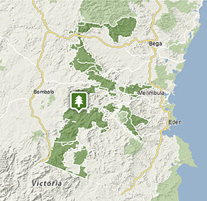
There are many access points for South East Forest National Park and directions will vary depending on which part of the park you would like to visit. General directions are below.
From Merimbula or Pambula, travel south along the Princes Highway. Turn right at Mount Darragh Road for access to Goodenia Rainforest and Wolumla Peak or continue further west towards Bombala.
From Bombala, travel east along Mount Darragh Road and look for signposts to visitor areas within the park.
From Bega, take the Princes Highway south before turning onto Candelo Bega Road, then take Myrtle Mountain Road from Candelo.
Park entry points
- Mount Darragh Road See on map
Parking
- Myanba Gorge lookout See on map
- Nunnock campground See on map
- Waalimma picnic area See on map
- Waratah Gully campground See on map
By bike
Check out the Bicycle information for NSW website for more information.
Best times to visit
There are lots of great things waiting for you in South East Forest National Park. Here are some of the highlights.
Autumn
Head to the Bombala River in the early morning or late afternoon to see platypuses - look for circular ripple patterns in the water.
Spring
See Nunnocks Swamp and grasslands in its spring bloom glory.
Summer
A great time for a walk in the park – try the easy Goodenia Rainforest walk through a lush gully of ferns covered by a dense canopy of tall lilly pilly trees.
Winter
After a day exploring, get cosy in front of an open fire at historic Alexanders Hut, Nunnocks Swap.
Facilities
Toilets Show more
- Alexanders Hut campground
- Goodenia Rainforest picnic area
- Myanba Gorge lookout
- Myrtle Mountain lookout
- Nunnock campground
- Pipers lookout
- Postmans campground
- Six Mile Creek campground
- Waalimma picnic area
- Waratah Gully campground
- White Rock River picnic area
Picnic tables Show more
- Alexanders Hut campground
- Goodenia Rainforest picnic area
- Myanba Gorge lookout
- Myrtle Mountain lookout
- Nunnock campground
- Pipers lookout
- Postmans campground
- Six Mile Creek campground
- Waalimma picnic area
- White Rock River picnic area
Barbecue facilities Show more
Maps and downloads
Prohibited
Pets
Pets and domestic animals (other than certified assistance animals) are not permitted. Find out which regional parks allow dog walking and see the pets in parks policy for more information.
Smoking
NSW national parks are no smoking areas.

Contact
- in the South Coast and Snowy Mountains regions
South East Forest National Park is always open but may have to close at times due to poor weather or fire danger.
-
-
Bombala office
02 6458 5900
Contact hours: Monday to Friday, 8.30am to 4pm. - 153 Maybe Street, Bombala NSW 2632
-
Email: npws.sapphirecoast@environment.nsw.gov.au
-
Bombala office
-
-
Merimbula office
02 6495 5000
Contact hours: Monday to Friday and some weekends during peak holiday periods, 10am to 3pm. - 47 Merimbula Drive, cnr Sapphire Coast Drive, Merimbula NSW 2548
-
Email: npws.sapphirecoast@environment.nsw.gov.au
-
Merimbula office
Nearby towns
Bombala (36 km)
Bombala is a pretty southern Monaro district town on the shores of the Bombala River. It features rolling pastures and dense native forests.
Merimbula (54 km)
The main coastal towns of the Sapphire Coast include Bermagui, Tathra, Merimbula and Eden. This stunning coastline has sparkling beaches and bays, lakes and national parks, all accessible via excellent walking tracks and coastal drives. You'll find beaches just perfect for surfing, swimming and walks.
Eden (75 km)
Eden is a historic whaling town, ideal for a whale-watch tour. It's built around a promontory that juts into Twofold Bay.
