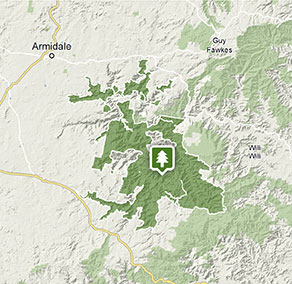
Oxley Wild Rivers National Park
Visitor info
All the practical information you need to know about Oxley Wild Rivers National Park.
Getting there and parking
Get driving directions
From Walcha and Armidale there are numerous turnoffs along the Waterfall Way and Oxley Highway. Look for road signs to visitor sites within the park.
Park entry points Show more
- Apsley Falls access See on map
- Halls Peak access See on map
- Long Point access See on map
- Riverside access See on map
- Tia Falls access See on map
- Wollomombi Falls access See on map
- Youdales access See on map
Parking Show more
- Apsley Falls campground See on map
- Apsley Falls picnic area See on map
- Blue Hole picnic area See on map
- Dangars Falls picnic area See on map
- Dangars Gorge campground See on map
- Gara Gorge lookout See on map
- Long Point campground and picnic area See on map
- Threlfall picnic area See on map
- Tia Falls picnic area See on map
- Wollomombi campground See on map
- Wollomombi Falls picnic area See on map
Road quality
- Unsealed roads
Weather restrictions
- 4WD required in wet weather
By bike
Check out the Bicycle Information for NSW website for more information.
By public transport
For more information about public transport options, visit the Transport NSW website.
Best times to visit
There are lots of great things waiting for you in Oxley Wild Rivers National Park. Here are some of the highlights.
Autumn
A great time to explore one of the longer bushwalks in the area and take in the scenic river views.
Spring
Admire the colourful wildflowers which are beautiful in the spring.
Summer
The water in the river at this time of year is generally warmer than on the Tableland, making it perfect for swimming and canoeing.
Winter
Crisp, cool and clear days are good for a brisk half day bushwalk.
Facilities
Toilets Show more
- Apsley Falls campground
- Apsley Falls picnic area
- Blue Hole picnic area
- Budds Mare campground and picnic area
- Budds Mare lookout
- Dangars Falls picnic area
- Dangars Gorge campground
- East Kunderang Homestead
- Gara Gorge lookout
- Halls Peak campground and picnic area
- Long Point campground and picnic area
- Riverside campground and picnic area
- Salisbury Waters walking track
- The Green Gully track
- Threlfall picnic area
- Tia Falls campground
- Tia Falls picnic area
- Wollomombi campground
- Wollomombi Falls picnic area
- Youdales Hut campground and picnic area
Picnic tables Show more
- Apsley Falls campground
- Apsley Falls picnic area
- Blue Hole picnic area
- Budds Mare campground and picnic area
- Budds Mare lookout
- Dangars Falls picnic area
- Dangars Gorge campground
- East Kunderang Homestead
- Gara Gorge lookout
- Halls Peak campground and picnic area
- Long Point campground and picnic area
- Riverside campground and picnic area
- The Green Gully track
- Threlfall picnic area
- Tia Falls campground
- Tia Falls picnic area
- Wollomombi Falls picnic area
- Youdales Hut campground and picnic area
Barbecue facilities Show more
Drinking water
Public phone
Showers
Electric power
Maps and downloads
Fees and passes
There are 3 areas in Oxley Wild Rivers National Park where you'll need day use vehicle permits: Halls Peak campground and picnic area, Riverside campground and picnic area, and Youdales Hut campground and picnic area. Day use vehicle permits can be bought online or by calling the National Parks Contact Centre on 1300 072 757. If camping, permit fees are included in the campground fee.
Prohibited
Pets
Pets and domestic animals (other than certified assistance animals) are not permitted. Find out which regional parks allow dog walking and see the pets in parks policy for more information.
Smoking
NSW national parks are no smoking areas.

Contact
- in the North Coast and Country NSW regions
Oxley Wild Rivers National Park is always open but may have to close at times due to poor weather or fire danger.
-
There are 3 areas in Oxley Wild Rivers National Park where you'll need day use vehicle permits: Halls Peak campground and picnic area, Riverside campground and picnic area, and Youdales Hut campground and picnic area. Day use vehicle permits can be bought online or by calling the National Parks Contact Centre on 1300 072 757. If camping, permit fees are included in the campground fee.
Contact us for permits -
-
Armidale office
02 6738 9100
Contact hours: Monday to Friday, 8.30am to 5pm. - 145 Miller Street, Armidale NSW 2350
-
Email: npws.nea@environment.nsw.gov.au
-
Armidale office
-
-
Walcha office
02 6777 4700
Contact hours: Monday to Friday, 8.30am to 4.30pm. - 188W North Street, Walcha NSW 2354
-
Email: npws.nea@environment.nsw.gov.au
-
Walcha office
Nearby towns
Walcha (18 km)
Walcha is the gateway to some of the best adventure experiences in Australia. Expect gorges, rainforests, waterfalls and wilderness. Enjoy helicopter flights, 4WD tours and fishing, as well as guided bushwalks in some of Australia's most rugged terrain.
Armidale (39 km)
During autumn the parks and gardens around Armidale show their beautiful colours. Enjoy a drive along the Waterfall Way, stopping at waterfalls and craggy gorges in the rugged countryside.
Dorrigo (87 km)
Dorrigo is a serene country town and the gateway to Dorrigo National Park. Its close to the edge of the escarpment above the Bellingen Valley.
