Murramarang Aboriginal Area
Visitor info
All the practical information you need to know about Murramarang Aboriginal Area.
Getting there and parking
Get driving directions
From Ulladulla:
- Follow Princes Highway south to Termeil
- Turn left onto Bawley Point Road and drive to its end
- Turn right into Murramarang Road
- About 2.5km down the road, you’ll come to Sand Mines carpark on the left.
- There’s a 600m walking track from here to the boundary of the reserve
Park entry points
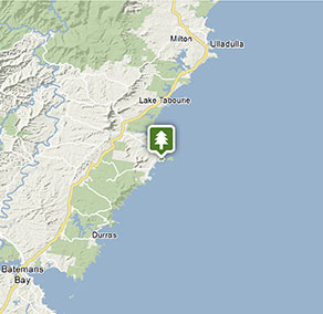
- Sand Mines carpark See on map
By bike
Check out the Bicycle information for NSW website for more information.
By public transport
For information about public transport options, visit the NSW country transport info website
Best times to visit
There are lots of great things waiting for you at Murramarang Aboriginal Area. Here are some of the highlights.
Spring
The coastal vegetation comes to life when the wildflowers bloom, and the temperature is perfect for taking the Murramarang Aboriginal Area walk.
Summer
It's a great time for enjoying the sea, so take a dip in the ocean, snorkel off the rocks, or bring your board to catch a wave.
Weather, temperature and rainfall
Summer temperature
Average
16°C and 25°C
Highest recorded
43.3°C
Winter temperature
Average
7°C and 16°C
Lowest recorded
0°C
Rainfall
Wettest month
March
Driest month
August
The area’s highest recorded rainfall in one day
275.3mm
Maps and downloads
Prohibited
Pets
Pets and domestic animals (other than certified assistance animals) are not permitted. Find out which regional parks allow dog walking and see the pets in parks policy for more information.
Smoking
NSW national parks are no smoking areas.

Contact
- in the South Coast region
Murramarang Aboriginal Area is always open but may have to close at times due to poor weather or fire danger.
-
-
Ulladulla office
02 4454 9500
Contact hours: Monday to Friday, 9am to 4pm. - Lot 9 Blackburn Industrial Estate, 6 Coller Road Ulladulla NSW 2539
-
Email: npws.shoalhaven@environment.nsw.gov.au
-
Ulladulla office
Nearby towns
Bawley Point (1 km)
Some of the beaches around Bawley Point are popular with surfers looking for the best waves along the coast. But there are plenty of other beaches where you can swim, picnic or simply watch kangaroos enjoying the surf.
Ulladulla (28 km)
Ulladulla is close to several wonderful national parks. Morton National Park, to the west, is home to Pigeon House Mountain, a local landmark which is a popular climb. Murramarang National Park, between Ulladulla and Batemans Bay, has beautiful coastal walks, beaches and camping sites.
Batemans Bay (40 km)
Batemans Bay is a bustling coastal town with majestic seascapes. It's located on the estuary of the Clyde River.
