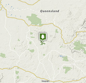
Kwiambal National Park
Visitor info
All the practical information you need to know about Kwiambal National Park.
Getting there and parking
Get driving directions
From Inverell:
- Travel along Byron Street through the town centre passing Kamilaroi Park on your left.
- Head north along Ashford Road for about an hour, and once at Ashford turn left onto Frazer Street.
- Follow Frazer Street as it turns onto Wallangra Road and head west to the intersection with Sandy Creek Road.
- Turn right onto Sandy CReek Road and follow for 6km until the intersection with Limestone Road.
- From here turn left and continue onto Kwiambal National Park.
From Tenterfield:
- Head west along the Bruxner Way for about an hour.
- Turn south just before Bonshaw to the small town of Ashford
- From here, travel along Inverell Street in Ashford and turn onto Limestone Road. Following this road for 16km and at the insection of Limestone Road and Sandy Creek Road turn right, and continue onto Kwiambal National Park.
Park entry points
- Goberts Road access See on map
- Limestone Road access See on map
Parking
- Dungeon lookout See on map
- Kookibitta campground See on map
- Lemon Tree Flat campground See on map
- Macintyre Falls lookout See on map
By bike
Check out the Bicycle information for NSW website for more information.
Best times to visit
There are lots of great things waiting for you in Kwiambal National Park. Here are some of the highlights.
Autumn
The crisp air offers excellent conditions for exploring either on foot or by mountain bike.
Spring
Many of the wildflowers are in bloom; including the pale-pink common fringe myrtle; native fuchsia, with its red bell-shaped flowers, and the yellow bitter-peas.
Summer
The many swimming opportunities, including rivers, secluded beaches, and even a plunge pool, makes Kwiambal a terrific destination in the height of summer.
Weather, temperature and rainfall
Summer temperature
Average
16°C and 30°C
Highest recorded
43.7°C
Winter temperature
Average
5°C and 16°C
Lowest recorded
–2.8°C
Rainfall
Wettest month
August
Driest month
February
The area’s highest recorded rainfall in one day
124mm
Facilities
Toilets Show more
- Dungeon lookout
- Kookibitta campground
- Lavender Vale Cottage
- Lavender Vale Homestead
- Lemon Tree Flat campground
- Macintyre Falls lookout
Picnic tables
Barbecue facilities Show more
Drinking water
Showers
Electric power
Maps and downloads
Prohibited
Pets
Pets and domestic animals (other than certified assistance animals) are not permitted. Find out which regional parks allow dog walking and see the pets in parks policy for more information.
Pets and domestic animals (other than certified assistance animals) are not permitted. For more information, please see the OEH policy.
Smoking
NSW national parks are no smoking areas.

Contact
- in the Country NSW region
Kwiambal National Park is always open but may have to close at times due to poor weather or fire danger.
-
-
Glen Innes office
02 6739 0700
Contact hours: Monday to Friday, 8.30am to 4.30pm. - 68 Church Street, Glen Innes NSW 2370
-
Email: npws.ntab@environment.nsw.gov.au
-
Glen Innes office
Nearby towns
Warialda (71 km)
Warialda is surrounded by picturesque bushland, making it an ideal location for bushwalking and relaxing in natural surrounds. There are numerous places to picnic, and Cranky Rock Nature Reserve is a popular spot for fossicking, birdwatching and exploring. The area also supports a large variety of wildflowers.
Inverell (80 km)
Go fossicking for sapphires and other gems at several places around the city. Grab a map of local fossicking sites from the visitor information centre and try your luck.
Glen Innes (118 km)
Set in the most prolific sapphire region of Country NSW, Glen Innes hosts the annual Minerama Fossicking and Gem Show and the annual Australian Celtic Festival, and is home to the Australian Standing Stones.
