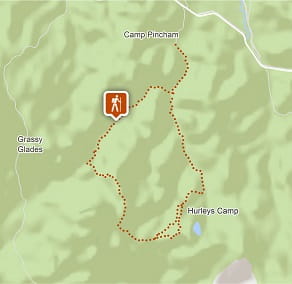
Breadknife and Grand High Tops walk
Warrumbungle National Park
Visitor info
All the practical information you need to know about Breadknife and Grand High Tops walk.
Track grading
Features of this track
Distance
14.5km loop
Time
5 - 6hrs
Quality of markings
Sign posted
Experience required
Some bushwalking experience recommended
Gradient
Very steep
Steps
Many steps
Quality of path
Formed track, some obstacles
Getting there and parking
Get driving directions
Breadknife and Grand High Tops walk is in the Pincham carpark precinct of Warrumbungle National Park. To get there:
From Coonabarabran:
- Follow John Renshaw Parkway into Warrumbungle National Park
- Turn left into Pincham Road approximately 100m past the Visitor Centre turnoff and continue to the end.
Parking
Parking is available at Camp Pincham carpark.
Best times to visit
You may experience a great range of temperatures on any day in the park. In summer it's generally hot in the daytime and temperatures often exceed 30C. In contrast, winter can be very cold and the temperature drops below freezing at night. Rainfall is also highly variable, ranging from drought to prolonged wet periods. Less rain falls on the western side of the park than on the eastern side. It rains most from December to February and the annual average rainfall is 720mm. Thunderstorms are common in mid to late summer.
Spring
During early spring wildflowers are in bloom, including a huge variety of golden wattle flowers With a more moderate climate, spring is a great time to get out and camp under the stars .
Weather, temperature and rainfall
Summer temperature
Average
15°C and 30°C
Highest recorded
42.6°C
Winter temperature
Average
0°C and 15°C
Lowest recorded
-9°C
Rainfall
Wettest month
January
Driest month
September
The area’s highest recorded rainfall in one day
176.3mm
Maps and downloads
Permitted
Rock climbing is permitted everywhere except the Breadknife and Chalkers Mountain. You'll need to register at the Visitor Centre before you head out.
Prohibited
Drones
Flying a drone for recreational purposes is prohibited in this area. Drones may affect public enjoyment, safety and privacy, interfere with park operations, or pose a threat to wildlife. See the Drones in Parks policy.
This area may be a declared Drone Exclusion Zone, or may be subject to Civil Aviation Safety Authority (CASA) rules for flying near airports, aerodromes and helicopter landing sites. See CASA's Drone Flyer Rules.
Commercial filming and photography
Commercial filming or photography is prohibited without prior consent. You must apply for permission and contact the local office.
Pets
Pets and domestic animals (other than certified assistance animals) are not permitted. Find out which regional parks allow dog walking and see the pets in parks policy for more information.
Smoking
NSW national parks are no smoking areas.

Operated by
- Warrumbungle NP Visitor Information Centre
- 9am to 4pm daily. Closed Christmas Day.
- 02 6825 4364
- warrumbungle.np@environment.nsw.gov.au
- 4261 John Renshaw Parkway, Warrumbungle NSW 2828
Park info
- in Warrumbungle National Park in the Country NSW region
Warrumbungle National Park is always open but may have to close at times due to poor weather or fire danger.
-
Park entry fees:
$8 per vehicle per day.
Buy annual pass
Visitor centre
-
Warrumbungle Visitor Centre
4261 John Renshaw Parkway, Warrumbungle NSW 2828 - 9am to 4pm daily. Closed Christmas Day.
- 02 6825 4364
