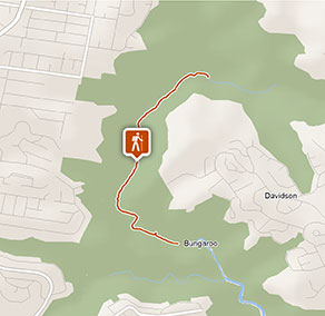
Stepping Stone Crossing to Cascades trail
Garigal National Park
Visitor info
All the practical information you need to know about Stepping Stone Crossing to Cascades trail.
Track grading
Features of this track
Distance
2.6km one-way
Time
27min - 1hr
Quality of markings
Clearly sign posted
Experience required
Some bushwalking experience recommended
Gradient
Gentle hills: The walk has short, steep inclines, including places where you'll need to climb up or down rock shelves.
Quality of path
Formed track, some obstacles: The walk is 1m-wide and a mix of hard-packed ground, soft sand and rock.
Steps
Occasional steps: There are 33 built steps on this walk, along with many natural rock steps that are scattered all the way along the track.
Other barriers
Gates: There are no gates along the walk itself, but all the access trails that lead to the start of this walk have vehicle gates. Some of these gates only have narrow gaps for pedestrians to get around them.
Pinch points: The track narrows at points where it goes between trees and rocks.
Other barriers:
- There are many points along the walk where there are protruding tree roots or old trees across the track that you'll need to climb over.
- There are 3 water crossings, 2 that appear after rain and one that's permanent.
- To get to the start of the track, you'll need to walk along access trails for at least 1.5km and up to 3km, depending on where you park.
Getting there and parking
Get driving directions
Stepping Stone Crossing to Cascades trail is in the central precinct of Garigal National Park. To get there:
- From Belrose: From the end of Rawson Parade, take the road past the large repeater tower (right) and house (left) to the signposted 'Heath trail' intersection (to the right), then take Heath track, Bare Creek track and Cascades trail for approximately 3.7km to Cascades.
- From St Ives: From Douglas Street near Acron Oval, take Cascades trail for approximately 1.3km to Cascades at Middle Harbour Creek.
- From St Ives: Enter Pipeline trail from Hunter Avenue, turn left and walk approximately 300m to the signposted start of Bungaroo track on the left, then take Bungaroo track to Stepping Stone Crossing over Middle Harbour Creek to Middle Harbour Creek track.
- From Davidson: From Stone Parade, take Cascades trail for approximately 1.5km to Cascades at Middle Harbour Creek.
- From Davidson: From John Oxley Drive, take Davidson trail to Governor Phillip walk, turn right and walk for approximately 500m to Stepping Stone Crossing to join Middle Harbour Creek track.
- From Forestville: From Davidson Park, take Lyrebird track and Governor Phillip walk for 3.8km to Stepping Stone Crossing and Middle Harbour Creek track.
Parking
Street parking is available nearby along the end of Stone Parade, John Oxley Drive (Davidson) and Douglas Street or Hunter Avenue (St Ives). There's also street parking at Ferguson Street, Forestville.
It can be a busy place on the weekend, so parking might be limited.
Best times to visit
There are lots of great things waiting for you in Garigal National Park. Here are some of the highlights.
Spring
Spot wildflowers turning the undergrowth into a painter's palette along the Cascades trail during late winter and early spring.
Summer
Davidson Park is a popular place for a family picnic or barbecue, so pack up the kids and a tasty lunch to enjoy some time in the great outdoors.
Weather, temperature and rainfall
Summer temperature
Average
18°C and 26°C
Highest recorded
44°C
Winter temperature
Average
10°C and 16°C
Lowest recorded
-1.7°C
Rainfall
Wettest month
March
Driest month
September
The area’s highest recorded rainfall in one day
290mm
Maps and downloads
Accessibility
Disability access level - no wheelchair access
Stepping Stone Crossing to Cascades trail is a 1m-wide walk that's a mixture of hard-packed ground, soft sand and rock.
The walk is not suitable for wheelchairs or prams and may be challenging for people with reduced mobility:
- There are short, steep inclines, including places where you'll need to climb up or down rock shelves.
- There are 33 built steps and many natural rock steps
- There are protruding tree roots and old trees across the track that you'll need to climb over
- There are 3 water crossings, 2 that appear after rain and one that's permanent.
- The track narrows at points where it goes between trees and rocks
To get to the start of the track, you'll need to walk along access trails for at least 1.5km, depending on where you park. All access trails have gates, some with only narrow gaps for pedestrians to get around them.
Check the weather before you set out as the access trails and the track can become boggy when it rains.
Prohibited
Cycling
Cycling is not permitted on this track.
Gathering firewood
Gathering firewood and the use of heat beads is not permitted.
Pets
Pets and domestic animals (other than certified assistance animals) are not permitted. Find out which regional parks allow dog walking and see the pets in parks policy for more information.
Smoking
NSW national parks are no smoking areas.

Operated by
- Forestville Office
- Monday to Friday, 9.30am to 4pm.
- 02 9451 3479
- npws.sydneynorth@environment.nsw.gov.au
- 82 Ferguson Street, Forestville NSW 2087
Park info
- in Garigal National Park in the Sydney and surrounds region
Garigal National Park is open 6am to 6.30pm (8pm during daylight savings) but may have to close at times due to poor weather or fire danger.
-
Park entry fees:
$8 per vehicle per day applies only at Davidson Park only. Day passes are available from on-park pay machines that accept coins and credit cards, and you can also pay for your visit via the Park’nPay app.
Bus: $4.40 per adult, $2.20 per child (per day).
Daily entry fee exemption for teachers and educational supervisors (1 adult per 10 children) applies only for organised and pre-arranged group bookings.
Buy annual pass
