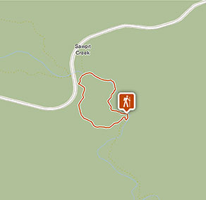
Sawpit walking track
Thredbo-Perisher area in Kosciuszko National Park
Visitor info
All the practical information you need to know about Sawpit walking track.
Track grading
Features of this track
Distance
2km loop
Time
45min - 1hr 15min
Quality of markings
Clearly sign posted
Experience required
No experience required
Gradient
Gentle hills
Steps
Occasional steps
Quality of path
Formed track, some obstacles: From the picnic area where the walk begins, there's a 35m long paved section with a metal grille bridge that has handrails. The paved path is 1.1m wide and the bridge is 1.6m wide.
After the short paved part of the track, the walk becomes hard-packed ground that is around 1m wide and can get narrower in parts. The track is mostly flat with gentle hills, but can be uneven.
Other barriers
Pinch points: There are parts of the walk where the track narrows due to plants, rocks and tree roots. There's also a bridge on the eastern side of the loop that narrows to 0.5m wide.
Getting there and parking
Sawpit walking track starts at Sawpit Creek picnic area in the southern precinct of Kosciuszko National Park.
To get there:
- Drive along Kosciuszko Road from Jindabyne towards Perisher Valley
- 400m past Kosciuszko Education Centre, turn left into Kosciuszko Tourist Park
- Take the first left down a short dirt road to reach the picnic area
- Alternatively, the picnic area can be accessed via a short paved walk from Kosciuszko Education Centre.
Road quality
All 2WD vehicles need to carry snow chains in winter, between June and October long weekends, on:
- Kosciuszko Road (to Perisher)
- Guthega Road
- Alpine Way between Thredbo and Tom Groggin
Snow chains are recommended for all vehicles driving in the park, including 4WD and AWD, in the event of extreme weather. Read our snow driving in Kosciuszko tips.
Parking
Parking is available in a gravel carpark at Sawpit Creek picnic area. This carpark is not suitable for large vehicles such as buses, caravans and RVs.
There's also parking at Kosciuszko Education Centre, including bus parking.
Facilities
The nearest toilet is at Sawpit Creek picnic area, where this walk begins.
Maps and downloads
Accessibility
Disability access level - hard
There's a short 35m section of track at the start of the walk that's paved and includes a metal grille bridge that has handrails.
After the initial paved section:
- The track becomes hard-packed ground and narrows to 1m wide, with parts that are narrower still due to plants, rocks and tree roots.
- On the eastern side of the loop, there's a bridge that is only 0.5m wide.
- Because of the narrow bridge and the limited width and unevenness on the eastern side of the loop, this section of the track may be more difficult for people with reduced mobility to access.
The nearest toilet for this walk is at Sawpit Creek picnic area, where the walk begins. It's not an accessible toilet and you'll need to cross over grass to reach it.
Permitted
Fishing
You can fish in rivers and streams between the October and June long weekends. A current NSW recreational fishing licence is required to fish in all waters. Fishing in dams and lakes is permitted year-round, but some waterways may close temporarily or have restrictions. Refer to the NSW Recreational Freshwater Fishing Guide for information.
Prohibited
Cycling
Cycling, including fat bikes or snow bikes, is not permitted on this track.
Drones
Flying a drone for recreational purposes is prohibited in this area. Drones may affect public enjoyment, safety and privacy, interfere with park operations, or pose a threat to wildlife. See the Drones in Parks policy.
This area may be a declared Drone Exclusion Zone, or may be subject to Civil Aviation Safety Authority (CASA) rules for flying near airports, aerodromes and helicopter landing sites. See CASA's Drone Flyer Rules.
Commercial filming and photography
Commercial filming or photography is prohibited without prior consent. You must apply for permission and contact the local office.
Pets
Pets and domestic animals (other than certified assistance animals) are not permitted. Find out which regional parks allow dog walking and see the pets in parks policy for more information.
Smoking
NSW national parks are no smoking areas. The alpine resorts of Thredbo, Perisher, Charlotte Pass, Selwyn, Ski Rider and Kosciuszko Tourist Park are exempt, though some commercial and outdoor places within these resorts may have no smoking areas.

Operated by
- Snowy Region Visitor Centre
- 8.30am to 5pm daily. Closed Christmas Day.
- 02 6450 5600
- srvc@environment.nsw.gov.au
- 49 Kosciuszko Road, Jindabyne NSW 2627
Park info
- in the Thredbo-Perisher area of Kosciuszko National Park in the Snowy Mountains region
- The Thredbo-Perisher area is open all year, but some roads and trails may close due to weather conditions or park management issues. Kosciuszko Road is closed between Perisher and Charlotte Pass in winter (June to October long weekends).
-
Park entry fees apply on Alpine Way and Kosciuszko Road
Winter (June to October long weekends): $29 per vehicle per day (24hrs from purchase); motorcycles $12; bus passengers $11.45 per adult, $3.60 per child per day. Find out more about the winter entry surcharge.
Rest of Year: $17 per vehicle per day (24hrs); motorcycles $7; bus passengers $6.60 per adult, $2.20 per child per day.
Passes: Day passes, multi-day passes and annual All Parks Pass available from NPWS visitor centres, local agents and operating vehicle entry stations. Single and Multi-Day passes are also available via the Park'nPay app. Short Breaks Pass: $68 for 5 days park entry at price of 4 days (not valid winter).
Read our Annual Pass FAQs for information.
Buy annual pass
Visitor centre
-
Snowy Region Visitor Centre
49 Kosciuszko Road, Jindabyne NSW 2627 - 8.30am to 5pm daily. Closed Christmas Day.
- 02 6450 5600
