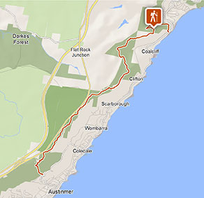
Forest walk to Sublime Point track
Illawarra Escarpment State Conservation Area
Visitor info
All the practical information you need to know about Forest walk to Sublime Point track.
Track grading
Features of this track
Distance
14km one-way
Time
5 - 6hrs
Quality of markings
Clearly sign posted
Experience required
Experienced bushwalkers
Gradient
Very steep
Steps
Many steps
Quality of path
Formed track, some obstacles
Getting there and parking
Get driving directions
Forest walk to Sublime Point track is in the Stanwell Park-Austinmer precinct of the Illawarra Escarpment State Conservation Area. To get there:
By car:
- From Stanwell Park, follow Lawrence Hargrave Drive for approximately 1.3km
- The walk begins at the Wodi Wodi trackhead, on the right.
Alternatively, if starting from Austinmer:
- From Lawrence Hargrave Drive, turn into Moore Street
- Crossover the railway bridge and continue straight along Balfour Road
- Turn left into Hill Street and take the next left into Foothills Road
- The walk begins at the Sublime Point trackhead, on the right.
By train:
- Take the South Coast line to Coalcliff station
- Walk north approximately 600m along Lawrence Hargrave Drive, to the Wodi Wodi trackhead. The walk finishes in Austinmer.
- Access to the Sublime Point trackhead is via Hill Street then Foothills Road
Parking
Parking is available on Lawrence Hargrave Drive, Coalcliff and Foothills Road, Austinmer. It can be a busy place on the weekend, so parking might be limited.
Best times to visit
There are lots of great things waiting for you in Illawarra Escarpment State Conservation Area. Here are some of the highlights.
Spring
Enjoy a native wildflower display on the Forest walk.
Summer
Cool your heels on the Mount Keira ring track, which threads through refreshing rainforest.
Winter
Take advantage of the escarpment elevation for a spot of whale watching north of Mount Keira, or from one of the several lookouts.
Weather, temperature and rainfall
Summer temperature
Average
16.5°C and 25.6°C
Highest recorded
42.3°C
Winter temperature
Average
8.3°C and 18.3°C
Lowest recorded
-0.5°C
Rainfall
Wettest month
April
Driest month
August
The area’s highest recorded rainfall in one day
316mm
Facilities
Drinking water
You'll need to bring your own drinking and cooking water
Maps and downloads
Prohibited
Camp fires and solid fuel burners
Fires are not permitted
Pets
Pets and domestic animals (other than certified assistance animals) are not permitted. Find out which regional parks allow dog walking and see the pets in parks policy for more information.
Smoking
NSW national parks are no smoking areas.

Operated by
- Wollongong office
- Monday to Friday, 8.30am to 4.30pm.
- 02 4224 4188
- npws.illawarrahighlands@environment.nsw.gov.au
- Unit G Ground Floor, 84 Crown Street, Wollongong NSW 2500
Park info
- in Illawarra Escarpment State Conservation Area in the South Coast region
Illawarra Escarpment State Conservation Area is always open but may have to close at times due to poor weather or fire danger. However, it is recommended that bushwalking only be undertaken during daylight hours because of the presence of cliff edges and other hazards.
