Bluff Mountain walking track
Warrumbungle National Park

Overview
Bluff Mountain walking track rewards experienced, fit bushwalkers with Warrumbungle National Park’s best views. This very long and challenging steep hike climbs past spectacular rock spires and domes—up to the summit of Bluff Mountain.
- Where
- Warrumbungle National Park in Country NSW
- Accessibility
- No wheelchair access
- Distance
- 17km loop
- Time suggested
- 7 - 8hrs
- Grade
- Grade 4
- Trip Intention Form
-
It's a good idea to let someone know where you're going. Fill in a trip intention form to send important details about your trip to your emergency contact.
- Personal Locator Beacon
-
Hire a Personal Locator Beacon (PLB) for free at Warrumbungle Visitor Centre.
- Entry fees
- Park entry fees apply
- What to
bring - Drinking water, sturdy shoes, topographic map, hat, sunscreen, snacks, suitable clothing
- Please note
- Bluff Mountain walking track is very long with steep sections and some loose rock. You’ll need a high level of fitness.
- This challenging hike suits walkers with a sense of adventure who like to tackle steep and technical terrain
- Bring at least 2L of water and some snacks with you on this strenuous hike. Drinking water is not available and water is scarce in this park.
- To break up the walk you can camp overnight at Balor Hut or Dows campgrounds which are located along this route.
- Visit Warrumbungle National Park Visitor Centre before you set out to register your name for the walk, pick up a free trail map and get detailed route information and advice.
A must for adventurous bushwalkers, Bluff Mountain walking track follows the same route as Breadknife and Grand High Tops walk but this hike takes you to the top of Bluff Mountain. It offers unrivalled views of the Warrumbungles’ ancient volcanic landscape as you climb from remnant ancient rainforest to windswept mountain heath.
You’ll start and end at Pincham carpark. From the carpark, walk Pincham trail, which follows Spirey Creek. Once you pass the Spirey View lookout, the steep climbing soon rewards you with views of the spectacular Breadknife and Belougery Spire. Near Balor Hut campground, take Grand High Tops trail to its summit for more outstanding views of the famous Breadknife. Or take Dagda Shortcut if your goal is to reach Bluff Mountain faster.
Pause at Dows Camp to gaze at Bluff Mountain’s imposing cliff face before you head for its summit. Straight at first, the summit trail zig zags and become less distinct as you climb over rocky outcrops, passing stunted trees and groves of big grass trees. Don’t forget to look up to see birds of prey riding air currents above the cliff face.
At the rocky summit of Bluff Mountain, settle down for a well deserved lunch and spectacular views of Mount Exmouth, Tonduron Spire and Mount Naman’s thick lava flows. Enjoy the park’s only views of Bluff Pyramid and the vast western plains.
When you’re ready to leave its lofty heights, climb back down to the main track. Head past Ogma Gap campground then follow West Spirey Creek track back to Pincham carpark.
Also see
-

Bluff Mountain lookout
Bluff Mountain lookout is in Warrumbungle National Park, at the end of Bluff Mountain walking track. At the summit of Bluff Mountain, this lookout rewards adventurous bushwalkers with remarkable views.
Map

Map
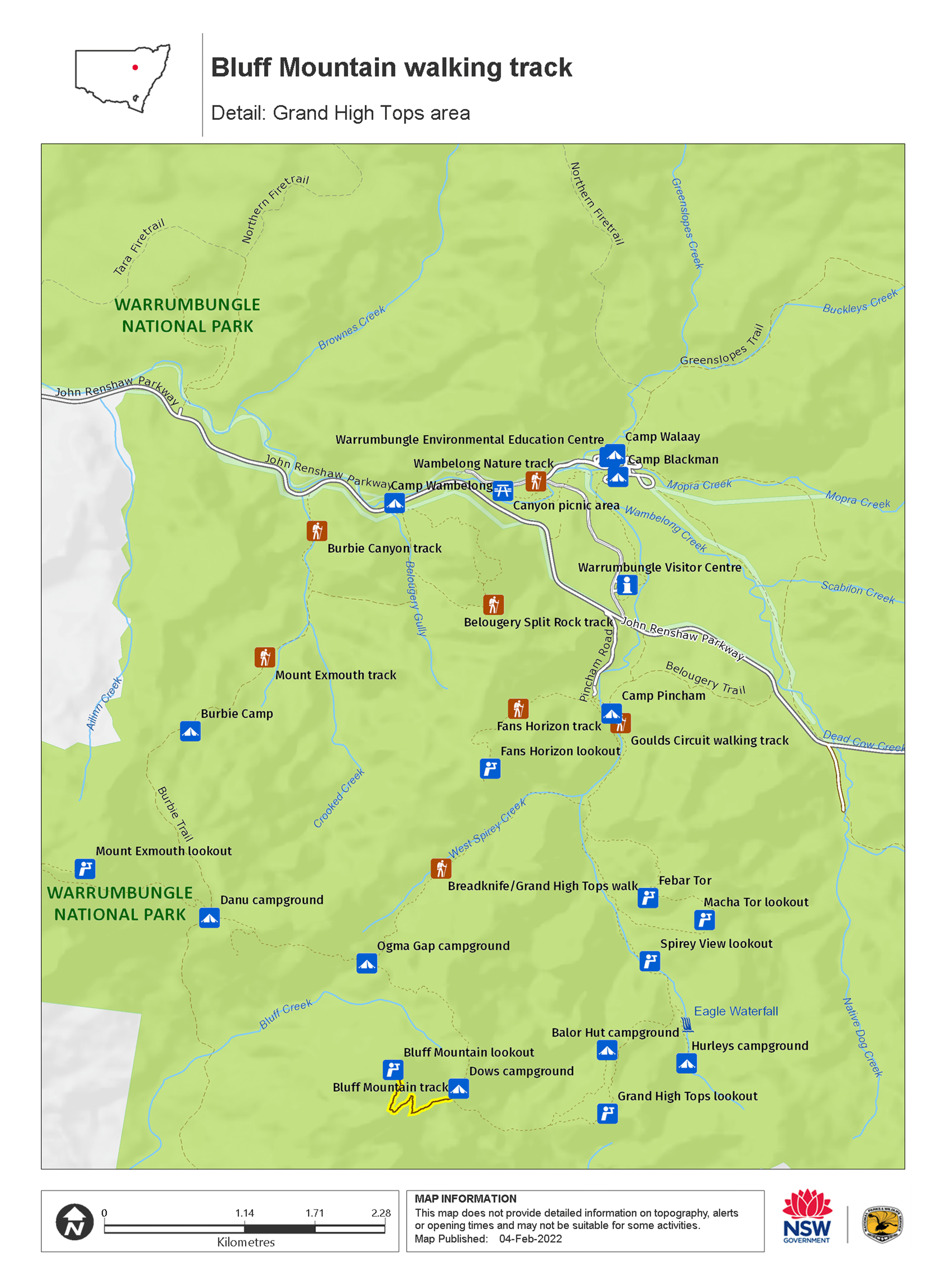
Map legend

Local alerts
For the latest updates on fires, closures and other alerts in this area, see https://www.nationalparks.nsw.gov.au/things-to-do/walking-tracks/bluff-mountain-walking-track/local-alerts
General enquiries
- National Parks Contact Centre
- 7am to 7pm daily
- 1300 072 757 (13000 PARKS) for the cost of a local call within Australia excluding mobiles
- parks.info@environment.nsw.gov.au
Park info
- in Warrumbungle National Park in the Country NSW region
Warrumbungle National Park is always open but may have to close at times due to poor weather or fire danger.
-
Park entry fees:
$8 per vehicle per day.
Buy annual pass.
Visitor info
All the practical information you need to know about Bluff Mountain walking track.
Track grading
Features of this track
Distance
17km loop
Time
7 - 8hrs
Quality of markings
Limited signage
Experience required
Experienced bushwalkers
Gradient
Very steep
Steps
Many steps
Quality of path
Rough track, many obstacles
Getting there and parking
Bluff Mountain walking track starts from Camp Pincham carpark in the central valley of Warrumbungle National Park—about 35km west of Coonabarabran. To get there from Coonabarabran:
- Follow John Renshaw Parkway into Warrumbungle National Park
- Turn left into Pincham Road around 100m past the visitor centre turnoff and continue to the end
Road quality
- Sealed roads
Vehicle access
- 2WD vehicles
Weather restrictions
- All weather
Parking
Parking is available at Pincham carpark
Facilities
Non-flush toilets are located at Pincham carpark where this walk starts and ends. There are also toilets at Balor Hut, which you'll pass along the way.
Carpark
Maps and downloads
Accessibility
Disability access level - no wheelchair access
Prohibited
Camp fires and solid fuel burners
Camping
You can’t camp on the walking track. Camping is available at Camp Pincham, Ogma campground or Balor Hut campground.
Cycling
Drones
Flying a drone for recreational purposes is prohibited in this area. Drones may affect public enjoyment, safety and privacy, interfere with park operations, or pose a threat to wildlife. See the Drones in Parks policy.
This area may be a declared Drone Exclusion Zone, or may be subject to Civil Aviation Safety Authority (CASA) rules for flying near airports, aerodromes and helicopter landing sites. See CASA's Drone Flyer Rules.
Commercial filming and photography
Commercial filming or photography is prohibited without prior consent. You must apply for permission and contact the local office.
Gathering firewood
Horses
Pets
Pets and domestic animals (other than certified assistance animals) are not permitted. Find out which regional parks allow dog walking and see the pets in parks policy for more information.
Smoking
NSW national parks are no smoking areas.
Visitor centre
-
Warrumbungle Visitor Centre
4261 John Renshaw Parkway, Warrumbungle NSW 2828 - 9am to 4pm daily. Closed Christmas Day.
- 02 6825 4364
Learn more
Bluff Mountain walking track is in Warrumbungle National Park. Here are just some of the reasons why this park is special:
Aboriginal dreamtime

Warrumbungle is a Gamilaraay word meaning crooked mountain, and for many thousands of years it has been a spiritual place for the custodians of this land, the Gamilaraay, the Wiradjuri and the Weilwan. The landscape, plants and animals of the park are a constant reminder of its sacred significance to Aboriginal people today. Take an Aboriginal Discovery guided tour to find out more about the Aboriginal cultural heritage.
- Tara Cave cultural tour Join this guided tour led by a local Aboriginal Discovery ranger. Discover the cultural heritage in the land of the Gamilaraay, Wiradjuri and Wailwan people in Warrumbungle National Park, near Coonabarabran.
- Tara Cave walking track Tara Cave walking track is a gentle 3.4km return bushwalk through Warrumbungle National Park, near Coonabarabran. Learn about local Aboriginal culture and experience remarkable views.
Diversity of wildlife

Warrumbungle National Park has a rich diversity of landforms and microclimates, and provides a habitat for hundreds of plant and animal species. Flourishing with wildflowers and unique plants, such as Warrumbungle Range wattle, Warrumbungle star flower, golden cassinia and grey ray flower, the area also has an abundance of rich birdlife, including emus, wedge-tailed eagles and turquoise parrots - just a few of over 190 bird species recorded in the park. If you're lucky, you may also spot wildlife such as the koala, squirrel glider and brush-tailed rock wallaby. Be sure to also keep an eye out for Warrumbungle black rock skink high on the mountains, and lace monitors rustling through the bush.
- Boots and brushes - guided walk and art tour Tap into your creativity on a 6km guided walk with a Discovery ranger in Warrumbungle National Park. Create your own personal artwork inspired by the iconic mountain landscape at Spirey View lookout.
- Burbie Canyon walking track Burbie Canyon walking track in Warrumbungle National Park offers a gentle 2km stroll through a sandstone gorge, and is particularly popular for birdwatching.
- Tara Cave cultural tour Join this guided tour led by a local Aboriginal Discovery ranger. Discover the cultural heritage in the land of the Gamilaraay, Wiradjuri and Wailwan people in Warrumbungle National Park, near Coonabarabran.
- Walk on the wild side at the Warrumbungles Join an experienced Discovery Ranger and explore the beauty of Warrumbungle National Park. This tour is designed to bring your senses alive as you explore the sights, sounds and smells of this beautiful area.
- Whitegum lookout walking track Whitegum lookout walking track is a short, wheelchair-accessible walk in Warrumbungle National Park. Suitable for all ages, it offers remarkable views.
Landscape and geology

The landscape of Warrumbungle National Park has been shaped by millions of years of volcanic activity and erosion; spend some time looking at Crater Bluff and Belougery Spire and imagine the vents of magma that once erupted to create these formations. Layers of lava and volcanic rock created Mount Exmouth and Mount Woorut just outside the boundary of the park, and Belougery Split Rock and Bluff Mountain are great examples of igneous lava domes. One of the most iconic features in the park, The Breadknife, is a volcanic dyke which stands a massive 90m tall. You can learn more about the park's fascinating geological history, or take a self-guided geology tour, through the NSW GeoTours app.
- Bluff Mountain walking track Bluff Mountain walking track rewards experienced, fit bushwalkers with Warrumbungle National Park’s best views. This very long and challenging steep hike climbs past spectacular rock spires and domes—up to the summit of Bluff Mountain.
- Boots and brushes - guided walk and art tour Tap into your creativity on a 6km guided walk with a Discovery ranger in Warrumbungle National Park. Create your own personal artwork inspired by the iconic mountain landscape at Spirey View lookout.
- Breadknife and Grand High Tops walk Breadknife and Grand High Tops walk in Warrumbungle National Park, regarded as one of the best walks in NSW, offers close up views of the park’s iconic rock formations.
- Burbie Canyon walking track Burbie Canyon walking track in Warrumbungle National Park offers a gentle 2km stroll through a sandstone gorge, and is particularly popular for birdwatching.
- Coonabarabran - Baradine - Warrumbungle drive Explore the spectacular landscapes, historic towns, picnic spots and walks of the Warrumbungles and Pilliga, near Coonabarabran and Baradine, in NSW.
Wish upon a star

Warrumbungle National Park is Australia’s first Dark Sky Park. Nearby Coonabarabran is known as the 'Astronomy Capital of Australia'. Stargaze from your campsite, or if you want to see right up to the heavens, visit a local observatory. The dramatic mix of volcanic spires and domes, plateaus, forested ridges and tall volcanic dykes are bound to make even the youngest of photographers look good, so whatever you do ‐ don't forget your camera.
- Canyon picnic area Canyon picnic area is a fully accessible, family friendly picnic area in Warrumbungle National Park. Not far from the visitor centre, it features barbecues and tables.
- Warrumbungle Visitor Centre Visitor information is available at the Warrumbungle Visitor Centre, which is now back in its original location. Get great suggestions and tips for walking and camping in Warrumbungle National Park.
- Whitegum lookout Whitegum lookout in Warrumbungle National Park features spectacular views of the landscape and picnic tables. It is wheelchair accessible and an easy walk for children.
Plants and animals protected in this park
Animals
-

Wedge-tailed eagle (Aquila audax)
With a wingspan of up to 2.5m, the wedge-tailed eagle is Australia’s largest bird of prey. These Australian animals are found in woodlands across NSW, and have the ability to soar to heights of over 2km. If you’re bird watching, look out for the distinctive diamond-shaped tail of the eagle.
-

Superb fairy wren (Malurus cyaneus)
The striking blue and black plumage of the adult male superb fairy wren makes for colourful bird watching across south-eastern Australia. The sociable superb fairy wrens, or blue wrens, are Australian birds living in groups consisting of a dominant male, mouse-brown female ‘jenny wrens’ and several tawny-brown juveniles.
-

Southern boobook (Ninox novaeseelandiae)
The southern boobook, also known as the mopoke, is the smallest and most common native owl in Australia. With a musical 'boo-book' call that echoes through forests and woodlands, the southern boobook is a great one to look out for while bird watching.
-

Tawny frogmouth (Podargus strigoides)
Found throughout Australia, the tawny frogmouth is often mistaken for an owl due to its wide, powerful beak, large head and nocturnal hunting habits. The ‘oom oom oom’ call of this native bird can be heard echoing throughout a range of habitats including heath, woodlands and urban areas.
-

Kookaburra (Dacelo novaeguineae)
Of the 2 species of kookaburra found in Australia, the laughing kookaburra is the best-known and the largest of the native kingfishers. With its distinctive riotous call, the laughing kookaburra is commonly heard in open woodlands and forests throughout NSW national parks, making these ideal spots for bird watching.