Boonoo Boonoo Falls picnic area
Boonoo Boonoo National Park

Overview
Boonoo Boonoo Falls picnic area is not only a great place to eat and rest, it teems with wildlife and wildflowers and is close to walking tracks, lookouts and Boonoo Boonoo Falls.
- Type
- Picnic areas
- Where
- Boonoo Boonoo National Park in Country NSW
- Accessibility
- Medium
- Entry fees
- Park entry fees apply
- What to
bring - Cooking water, drinking water, snacks, sunscreen, hat, clothes for all weather conditions
- Please note
- Check the weather before you set out as the road to Boonoo Boonoo Falls picnic area can become flooded during heavy rain
- The weather can be extreme and unpredictable, so please ensure you’re well-prepared for your visit.
- You'll need to bring drinking and cooking water
If Boonoo Boonoo National Park were a house, then Boonoo Boonoo Falls picnic area would be its living room. Not only is it an ideal place for a picnic or barbecue breakfast, lunch or dinner, but most other park attractions can be accessed from here.
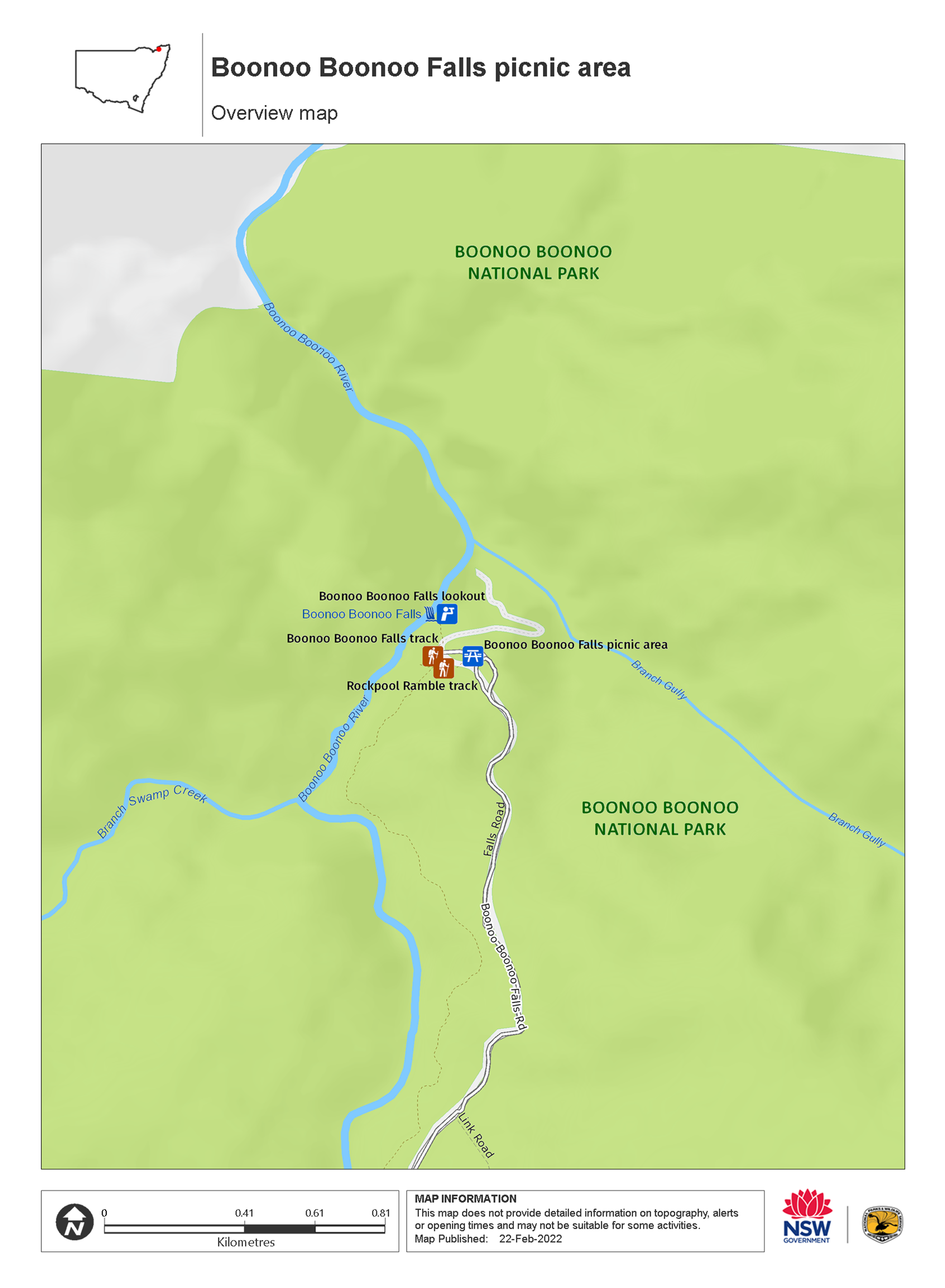
So meet up with friends, family, your birdwatching group or hiking crew and make the most of this great spot. From the picnic area, it’s only a short easy bushwalk along Boonoo Boonoo Falls walking track to the lookout. Here, you can gaze across the gorge to the awesome sight of Boonoo Boonoo River falling 210 metres down the side of the granite cliff face. Further on are swimming holes, the beginning of River track and access to other hiking trails.
Look out for wallabies and kangaroos around the picnic area, especially at either end of the day. Bring along your binoculars for a spot of birdwatching; woodland birds are often seen grazing in the overhead canopy.
Nearby


Map
Map legend

Local alerts
For the latest updates on fires, closures and other alerts in this area, see https://www.nationalparks.nsw.gov.au/things-to-do/picnic-areas/boonoo-boonoo-falls-picnic-area/local-alerts
General enquiries
- National Parks Contact Centre
- 7am to 7pm daily
- 1300 072 757 (13000 PARKS) for the cost of a local call within Australia excluding mobiles
- parks.info@environment.nsw.gov.au
Park info
- in Boonoo Boonoo National Park in the Country NSW region
Boonoo Boonoo National Park is always open but may have to close at times due to poor weather or fire danger.
-
Park entry fees:
$8 per vehicle per day. The park uses a self-registration fee collection system. Please bring the correct change.
Buy annual pass.
Visitor info
All the practical information you need to know about the Boonoo Boonoo Falls picnic area.
Getting there and parking
From Tenterfield:
- Turn right onto Naas Street at the northern end of Rouse Street, then turn left onto Logan Street.
- Drive for 21km down sealed Mount Lindesay Road, passing Basket Swamp National Park.
- Turn right onto sealed Boonoo Boonoo Falls Road, and drive for 5 km to the park entrance.
- Continue along unsealed Boonoo Boonoo Falls Road for 9 km to Boonoo Boonoo Falls picnic area where you can park.
From Stanthorpe:
- From High Street, turn right on Amosfield Road, then take a slight right towards Tenterfield along sealed Mount Lindesay Road.
- Crossing Mursons and Jenner Creeks, continue past Bald Rock National Park.
- Turn left onto sealed Boonoo Boonoo Falls Road, and drive for 5 km to the park entrance.
- Continue along unsealed Boonoo Boonoo Falls Road for 9 km to Boonoo Boonoo Falls picnic area where you can park.
Road quality
Check the weather before you set out as the road to Boonoo Boonoo Falls can become inaccessible during and after heavy rain
- Mixture of sealed and unsealed roads
Vehicle access
- 2WD vehicles
Weather restrictions
- All weather
Parking
Parking is available in a gravel carpark at Boonoo Boonoo Falls picnic area, including 1 designated accessible parking space. Bus parking is available.
Best times to visit
There are lots of great things waiting for you in Boonoo Boonoo National Park. Here are some of the highlights.
Spring
This is the season for wildflowers. The mild weather at this time of year is also particularly good for camping.
Summer
The water in the large secluded rock pools along the river will give sweet relief from the summer heat.
Winter
Temperatures can plunge overnight and mornings are often frosty at this time of year, so be well-prepared if you're camping. Though winter days are often sunny, cloudless and warm enough to enjoy a picnic or a long hike.
Weather, temperature and rainfall
Summer temperature
Average
14°C and 27°C
Highest recorded
38.3°C
Winter temperature
Average
2°C and 14°C
Lowest recorded
-10°C
Rainfall
Wettest month
January
Driest month
August
The area’s highest recorded rainfall in one day
228.6mm
Facilities
There are no rubbish bins so please take all your rubbish with you.
Toilets
There is a toilet that can be accessed by people with reduced mobility but not people in wheelchairs
- Non-flush toilets
Picnic tables
The picnic area has several picnic tables, including 1 that's wheelchair accessible.
Barbecue facilities
- Gas/electric barbecues (free)
- Wood barbecues (bring your own firewood)
Carpark
- There is a carpark with 1 accessible parking space.
- Bus parking is available just south of the picnic area.
Step-free access
The picnic area is mostly flat and step-free with a smooth bitumen pathway that leads to the picnic tables, barbecue shelter and one of the toilets.
You'll need to cross over gravel to reach the other parts of the picnic area that are not located along this pathway.
The ground has a slight slope from the picnic area down to the rockpool viewing area, with a gradient of 1:10.
- Step-free outdoor pathways
Maps and downloads
Accessibility
Disability access level - medium
Boonoo Boonoo Falls picnic area is mostly flat and step-free, with the following accessible facilities:
- 1 accessible parking spot in the gravel carpark
- A smooth bitumen pathway that runs from the carpark to the picnic tables, barbecue shelter and 1 of the toilets. This toilet is accessible by people with reduced mobility but not by people in wheelchairs.
- 1 wheelchair-accessible picnic table at the picnic area, set on a paved slab with a gable roof.
There are 2 non-flush toilets toilets at the picnic area. One is set along a bitumen pathway and the other is surrounded by gravel. Neither are ambulant.
Permitted
Fishing
Fishing from a boat, the beach, the rocks or by the river is a popular activity for many national park visitors. If you’re planning a day out fishing, check out these fishing and rock fishing safety tips.
Prohibited
Pets
Pets and domestic animals (other than certified assistance animals) are not permitted. Find out which regional parks allow dog walking and see the pets in parks policy for more information.
Smoking
NSW national parks are no smoking areas.
Learn more
Boonoo Boonoo Falls picnic area is in Boonoo Boonoo National Park. Here are just some of the reasons why this park is special:
Fabulous falls

The park's jewel is Boonoo Boonoo Falls. If you'd like to see what this feature is really made of, visit during the wetter months of summer. Even if the falls aren't pumping, though, they're still beautiful and there will always be rockpools along Boonoo Boonoo River to swim in, walking tracks to follow and riverside picnics to indulge in.
Gold fever

Morgans Gully and Ropers Gully are two sites in the park where alluvial gold was discovered in the late nineteenth century. As a result, there was a huge influx of European and Asian prospectors to the area. As well as giving the nearby town of Tenterfield a massive economic boost, the village of Boonoo Boonoo temporarily flourished, though it is now in ruins.
Though nature has reclaimed these gullies too, imagine what the areas might have looked, sounded and smelt like when they were teeming with men from here and all over the world, half-crazy with gold fever.
Have you seen the wildlife?

Boonoo Boonoo takes its name from the Jukambal language and means ‘big rock’. Known for its stunning waterfalls, secluded waterholes and many walking trails, this national park is home to many plants and animals including kangaroos, endangered brush-tailed rock-wallabies and vulnerable spotted-tailed quolls which you may see throughout the park in the early morning and late afternoon. You may also be lucky enough to spot platypuses frolicking in Boonoo Boonoo River.
- Boonoo Boonoo Falls picnic area Boonoo Boonoo Falls picnic area is not only a great place to eat and rest, it teems with wildlife and wildflowers and is close to walking tracks, lookouts and Boonoo Boonoo Falls.
- Falls Lookout walk For views of magnificent Boonoo Boonoo Falls, why not wander along Falls Lookout walk, only 35km from Tenterfield.
- Morgans Gully picnic area Visit Morgans Gully for a relaxing picnic, and investigate gold mining historic heritage surrounded by wildflowers and embellished with a waterfall and geological formations.
- River walk River walk offers excellent scenery, wildlife watching, swimming and picnicking. It connects Morgans Gully picnic area, Cypress Pine campground and Platypus Hole picnic area with Boonoo Boonoo Falls picnic area.
- Rockpool Ramble walk Rockpool Ramble walk is in Boonoo Boonoo National Park, near Tenterfield. It’s a great way to see Boonoo Boonoo River and its lovely rockpools.