Mullion Range State Conservation Area
Overview
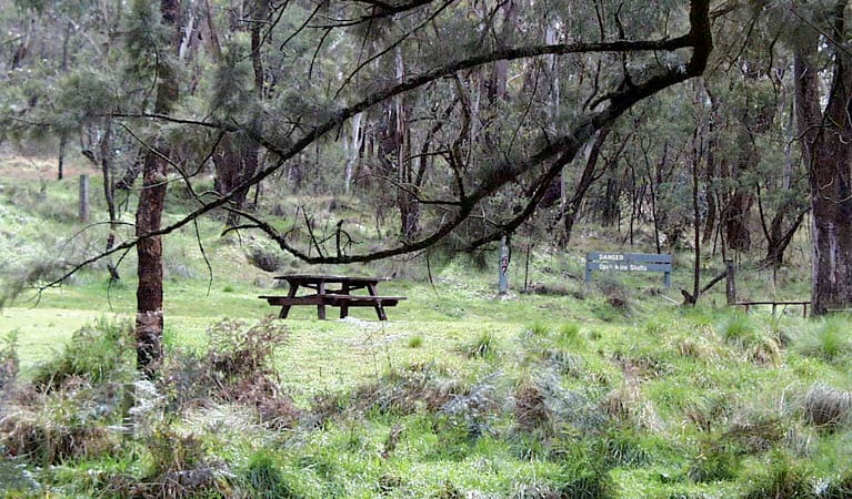
Visit Mullion Range State Conservation Area, between Orange and Ophir, to enjoy swimming, fishing, scenic lookouts and picnicking in an area rich in gold mining history.
Read more about Mullion Range State Conservation Area
Mullion Range State Conservation Area is a magical spot to tackle a bushwalk, relax over a picnic, gaze up at glorious waterfalls, or indulge in a spot of fishing and swimming in the crystal clear waters of Summer Hill creek.
The park is alive with interesting plant and animal life. Among the creatures you might encounter are lots of woodland birds, including colourful native parrots and owls, not to mention gliders, possums, and even platypus along the creek if you’re really lucky.
History buffs will enjoy checking out the remnants of the area’s gold mining past; follow Historic Water Race walking track, made by the pioneering gold miners in the 1860s, to discover a small slice of Orange’s gold mining heritage.
Or head out along Central Mines trail to The Falls for spectacular views and a splash in the rock waterholes at the bottom of the falls, followed by a delicious picnic.
Local alerts
For the latest updates on fires, closures and other alerts in this area, see https://www.nationalparks.nsw.gov.au/visit-a-park/parks/mullion-range-state-conservation-area/local-alerts
Contact
- in the Country NSW region
Mullion Range State Conservation Area is always open but may have to close at times due to poor weather or fire danger.
-
-
Bathurst office
02 6332 7640
02 6332 7680 To contact the KARST Conservation Unit in this office.
Contact hours: Monday to Friday, 8.30am to 4.30pm. - Level 2, 203-209 Russell Street, Bathurst NSW 2795
-
Email: npws.centralwest@environment.nsw.gov.au
-
Bathurst office
Visitor info
All the practical information you need to know about Mullion Range State Conservation Area.
Map

Map legend

Getting there and parking
Get driving directions
From Orange:
- To reach the Central Mines Trail carpark which is also the carpark for The Falls, travel north east along Ophir Road for 14km.
- To access the Fourth Crossing Picnic Area which marks the start of the Historic Water Race walking track, travel a further 4km along Ophir Road.
Parking
- Fourth Crossing picnic area See on map
Road quality
- Sealed roads
Vehicle access
- 2WD vehicles
Weather restrictions
- All weather
Parking
Gravel carparks
By bike
Check out the Bicycle information for NSW website for more information.
Best times to visit
There are lots of great things waiting for you at Mullion Range State Conservation Area. Here are some of the highlights.
Autumn
The cooler months are a great time for enjoying bushwalks, birdwatching and fishing.
Spring
Enjoy blooming wildflowers at Fourth Crossing picnic area. The perfume of wattles is stunning here.
Summer
Cool off with a swim in Summer Hill Creek, or go trout fishing.
Winter
The Falls are particularly striking when there are high level water flows after heavy rainfall.
Weather, temperature and rainfall
Summer temperature
Average
12°C and 28°C
Highest recorded
38.3°C
Winter temperature
Average
2°C and 13°C
Lowest recorded
-5.6°C
Rainfall
Wettest month
August
Driest month
April
The area’s highest recorded rainfall in one day
98.6mm
Facilities
Maps and downloads
Prohibited
Camp fires and solid fuel burners
Pets
Pets and domestic animals (other than certified assistance animals) are not permitted. Find out which regional parks allow dog walking and see the pets in parks policy for more information.
Smoking
NSW national parks are no smoking areas.
Nearby towns
Orange (14 km)
The bustling city of Orange, with its many cafes, restaurants and shopping opportunities, has something for everyone, plus there's a huge range of places to stay. The real highlight is the town's food and wine, so bring your thirst and your appetite.
Molong (48 km)
Follow the heritage walking tour of Molong in Country NSW to see the many fine 19th-century buildings. Wander through craft shops or art galleries and visit nearby historic villages such as Yeoval, Cumnock and Cudal.
Bathurst (65 km)
Within a 70-km radius of Bathurst are the spectacular limestone cave systems -Abercrombie and Jenolan caves - which you can explore safely on guided tours.
Learn more
Mullion Range State Conservation Area is a special place. Here are just some of the reasons why:
Unique plant and birdlife

You may spot interesting wildlife here, like eastern grey kangaroos, red-necked wallabies and wallaroos bounding through open fields. Gliders scurry among the treetops and platypus paddle their way along the creek. Large swathes of vegetation on the flatter areas of Mullion Range State Conservation Area have remained relatively undisturbed, thanks to the area's mining past. This means you can see a number of plant species and communities here that are rarely found elsewhere in central western NSW, including inland scribby gum, red stringybark and river oak. Mullion Range also provides habitat for many unique and interesting species of woodland birds, such as native parrots, including eastern rosellas and crimson rosellas, superb parrots in the springtime, and owls.
- Fourth Crossing picnic area Fourth Crossing picnic area next to Summer Hill Creek, near Orange, is a great base for exploring gold mining history on walking tracks, swimming or trout fishing.
- The Falls The Falls, near Summer Hill Creek in Mullion Range State Conservation Area, provide a scenic vista and popular swimming location.
Good as gold

Explore the past by discovering fascinating remnants of the Mullion's gold mining boom. From 1860 to 1920, intrepid gold mining pioneers created mining sites and a water race that was built by hand to transport water from the creek to the mining areas.
- Historic Water Race walking track Historic Water Race walking track, near Orange, is a medium-difficulty walk offering birdwatching and gold mining history as well as swimming and fishing along Summer Hill Creek.
- The Falls The Falls, near Summer Hill Creek in Mullion Range State Conservation Area, provide a scenic vista and popular swimming location.
Striking scenic water landscapes

A prominent feature of the landscape of this reserve is the mix of rocky outcrops and the waters of Summer Hill Creek.
Education resources (1)
What we're doing
Mullion Range State Conservation Area has management strategies in place to protect and conserve the values of this park. View the detailed park and fire management documents.