Ugly Corner Falls walking track
Torrington State Conservation Area
Overview
The Ugly Corner Falls walking track is a fantastic way to get back to nature and experience the unique plants and animals of Torrington.
- Distance
- 3km return
- Time suggested
- 1 - 2hrs
- Grade
- Grade 4
- What to
bring - Hat, sunscreen, drinking water
- Please note
- The weather in this area can be extreme and unpredictable, please ensure you are well prepared for your visit.
- Remember to take your binoculars if you want to birdwatch.
Meandering through the bush and along the creek, this walk is a fantastic way to get back to nature and experience unique plants and animals of Torrington State Conservation Area.
You’ll begin your walk on the old fire trail to the Oaky Creek. After a bit of rock hopping and a creek crossing the well-defined track takes you through wooded bush scattered with grass trees – strange looking stumpy trees with long blades of grass growing out the top. In spring and summer, look out for rare wildflower species like Beadle’s grevillia with its red and black toothbrush flowers and Torrington wattle.
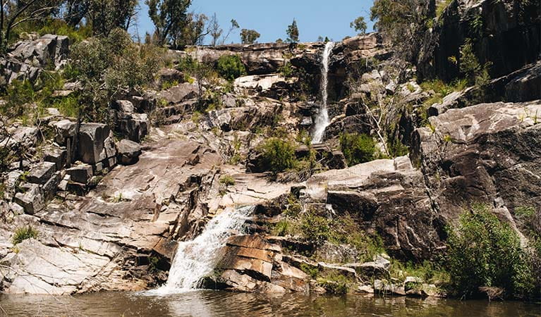
After approximately 1.5km you’ll arrive at Ugly Corner Falls. Best viewed after rain, they provide a tranquil spot to take in the scenery and peaceful surroundings before you head back the same way.
If you’re ready for a rest after your walk, why not head to the nearby Blatherarm campground and picnic area to enjoy a relaxing afternoon by the creek.
Map
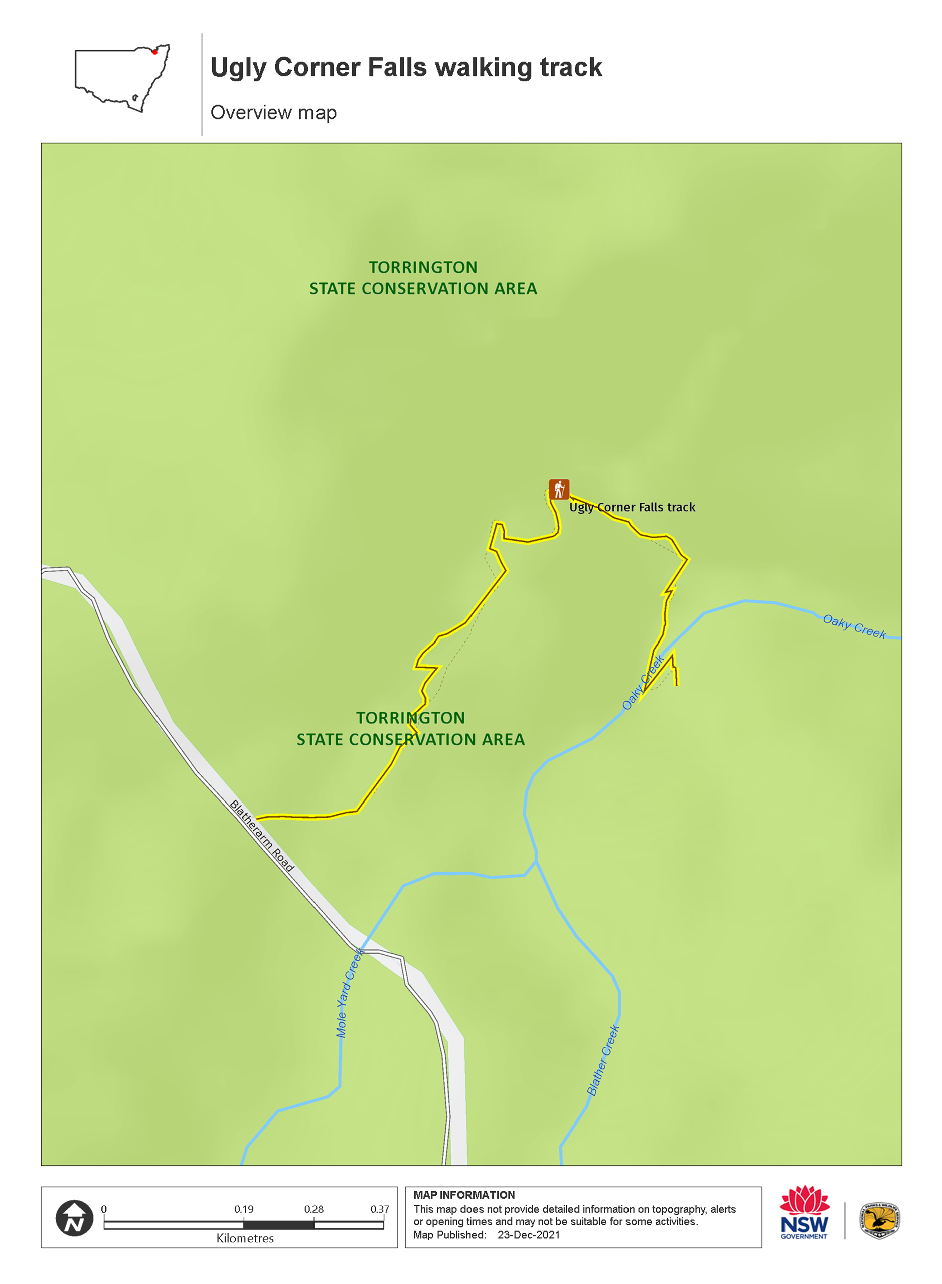
Map legend

Local alerts
For the latest updates on fires, closures and other alerts in this area, see https://www.nationalparks.nsw.gov.au/things-to-do/walking-tracks/ugly-corner-falls-walking-track/local-alerts
General enquiries
- National Parks Contact Centre
- 7am to 7pm daily
- 1300 072 757 (13000 PARKS) for the cost of a local call within Australia excluding mobiles
- parks.info@environment.nsw.gov.au
Park info
- in Torrington State Conservation Area in the Country NSW region
Torrington State Conservation Area is always open but may have to close at times due to poor weather or fire danger.
Visitor info
All the practical information you need to know about Ugly Corner Falls walking track.
Track grading
Features of this track
Distance
3km return
Time
1 - 2hrs
Quality of markings
Limited signage
Experience required
No experience required
Gradient
Short steep hills
Steps
Occasional steps
Quality of path
Formed track, some obstacles
Getting there and parking
Get driving directions
Ugly Corner Falls walking track is in the north-eastern precinct of Torrington State Conservation Area. To get there:
- After passing through the township of Torrington take a right turn at the old pub into Silent Grove Road
- Follow for approximately 10km to the Blatherarm Road turnoff on your right
- Ugly Corner Falls walking track and carpark are on your left after 1.5km
Road quality
Check the weather before you set out as the road to Ugly Corner Falls walking track can become boggy when it rains.
Parking
Parking is available at Ugly Corner Falls walking track.
Best times to visit
There are lots of great things waiting for you in Torrington State Conservation Area. Here are some of the highlights.
Spring
See the spectacular display of spring wildflowers as the boronias, grevilleas, prostantheras and many other native wildflowers turn the bush into a vibrant display of colour.
Summer
Wander through the bush, dotted with colourful wildflowers, as you take in the magnificent granite formations on the Mystery Face walking track.
Weather, temperature and rainfall
Summer temperature
Average
13°C and 31°C
Highest recorded
41.2°C
Winter temperature
Average
1°C and 19°C
Lowest recorded
-10.6°C
Rainfall
Wettest month
January
Driest month
June
The area’s highest recorded rainfall in one day
361.2mm
Maps and downloads
Permitted
Camp fires and solid fuel burners
You are encouraged to bring gas or fuel stoves, especially in summer during the fire season.
Prohibited
Gathering firewood
Firewood is not supplied and may not be collected from the park.
Pets
Pets and domestic animals (other than certified assistance animals) are not permitted. Find out which regional parks allow dog walking and see the pets in parks policy for more information.
Smoking
NSW national parks are no smoking areas.
Learn more
Ugly Corner Falls walking track is in Torrington State Conservation Area. Here are just some of the reasons why this park is special:
Bush experiences

Take in the dramatic views, magnificent rock formations and stunning wildflowers on the many walking tracks. Set up camp at Blatherarm campground or just spend an afternoon relaxing and picnicking at the various picnic areas. And if you are an experienced bushwalker looking for adventure, why not go exploring by foot into the remote corners in the north.
- Mystery Face walking track The magnificent rock formations on the Mystery Face walking track are a must-see for any Torrington visitor and great for birdwatching and springtime wildflower displays.
- Thunderbolts lookout walking track Follow this walking track to see the spectacular 360° panoramic views of Torrington at Thunderbolts lookout. Experience the stunning wildflowers along the way.
Fabulous flowers and wonderful wildlife

This area is home to over 750 plant species, including 45 rare or threatened species like the rare Beadle’s grevillia and Torrington wattle. In fact, some plant communities thrive in the sedge-heath swamps and mole granite outcrops and can’t be found anywhere else in the world. From September to March the bush is ablaze with colour for the spectacular wildflower display. The unique climatic conditions make Torrington a haven for Australian wildlife. It’s home to 20 mammal, 135 bird, 29 reptile and 13 frog species, including threatened species like the powerful owl and the tiger quoll. You’ll probably see grey kangaroos and wallabies in the distance, and kookaburras and currawongs in the trees overhead. But if you’re lucky, you might also spot rare birds like the striking turquoise parrot and rare regent honeyeater.
- Mystery Face walking track The magnificent rock formations on the Mystery Face walking track are a must-see for any Torrington visitor and great for birdwatching and springtime wildflower displays.
- Ugly Corner Falls walking track The Ugly Corner Falls walking track is a fantastic way to get back to nature and experience the unique plants and animals of Torrington.
Land of Dreaming

Torrington State Conservation Area is a significant place for the Ngarrabul, Marbul, Bigambul and Jucumbul people. The land and waterways of Torrington, and the plants and animals that live in them, feature in all facets of Aboriginal culture and are associated with dreaming stories told to this day.
Mining heritage

Go back in time to the by-gone era of mining on the Mole Tableland when hopefuls came from as far as England and China to explore the deposits of tin and other minerals. At its peak in the 1920s, Torrington and nearby villages swelled to accommodate around 600 miners, but sharply declined in 1946 when mining virtually stopped. Try your luck fossicking for semi-precious gemstones like beryl, emerald, topaz and quartz.