Jacks Creek walking track
Cocoparra National Park
Overview
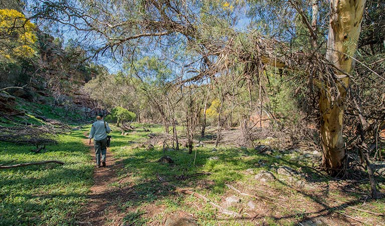
Jacks Creek walking track threads through a sheltered gorge and upon ridge tops. You’ll enjoy scenic views, plentiful birdwatching and diverse habitats.
- Where
- Cocoparra National Park in Murray-Riverina
- Accessibility
- Hard
- Distance
- 2.4km loop
- Time suggested
- 1 - 2hrs
- Grade
- Grade 3
- What to
bring - Drinking water, hat, sunscreen
Jacks Creek walking track gives your bushwalking a twist with the intriguing, varied habitats of Cocoparra National Park. Setting out from Jacks Creek picnic area, you’ll explore a vast gorge, walking through sheltered gullies and along exposed ridges. Three lookouts give scenic views of the gorge and surrounding landscape. After rain, the gorge is alive with running water, accompanied by frog song.
Look out for a variety of woodland birds overhead, peregrine falcons roosting in the cliffs and flying through the gorge, and white-winged choughs nesting above the tables in the picnic area. Look carefully at those shadows in the rock caves – they may be hiding swamp wallabies keen to avoid the heat of the day.
Map
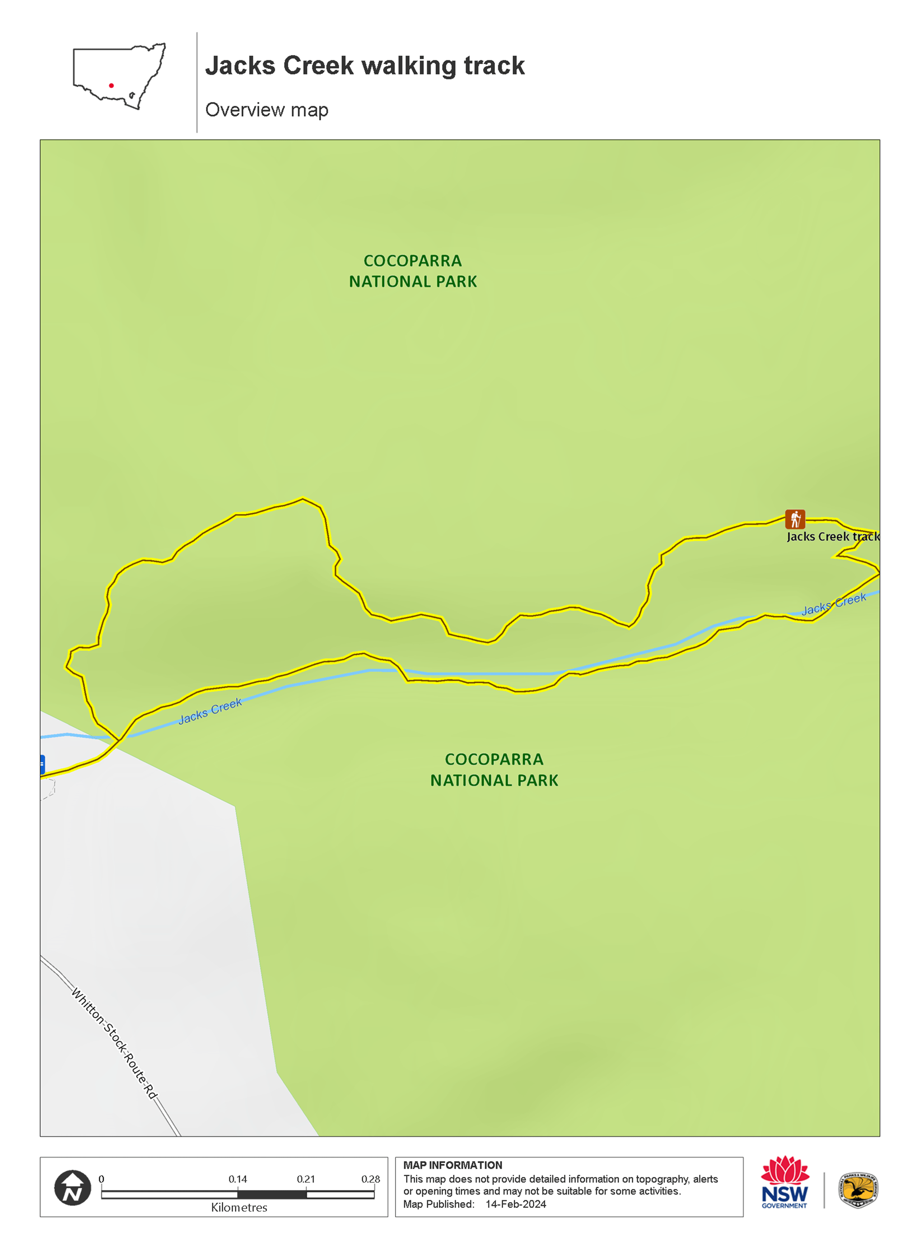
Map legend

Local alerts
For the latest updates on fires, closures and other alerts in this area, see https://www.nationalparks.nsw.gov.au/things-to-do/walking-tracks/jacks-creek-walking-track/local-alerts
General enquiries
- National Parks Contact Centre
- 7am to 7pm daily
- 1300 072 757 (13000 PARKS) for the cost of a local call within Australia excluding mobiles
- parks.info@environment.nsw.gov.au
Park info
- in Cocoparra National Park in the Murray-Riverina region
Cocoparra National Park is always open but may have to close at times due to poor weather or fire danger.
Visitor info
All the practical information you need to know about Jacks Creek walking track.
Track grading
Features of this track
Distance
2.4km loop
Time
1 - 2hrs
Quality of markings
Sign posted
Experience required
No experience required
Steps
Occasional steps
Gradient
Short steep hills: The first 350m of the track has gentle hills. The track becomes steeper after this, especially along the ridge section.
Quality of path
Formed track, some obstacles: The walk 2m-wide and hard-packed ground along its length, with some sections of loose gravel.
Other barriers
Other barriers:
- There are 25 regularly-spaced drainage bollards across the track that you'll need to step across.
- After the start of the gully and when you get to the ridge, the track is steep and rocky.
- There's a low vehicle barrier separating the carpark from the start of the walk, with a gap of 90cm.
Accessible options
The 350m section of the loop walk that leads from the carpark to the start of the gully may be suitable for people with reduced mobility.
After this point, the walk becomes very rocky and crosses a creek several times. There are many steep sections when the track reaches the ridge.
Getting there and parking
Jacks Creek walking track is in the Jacks Creek precinct of Cocoparra National Park. To get there:
- From Griffith, take Rankin Springs Road through Beelbangera village towards Yenda for approximately 16km
- Turn left onto Myall Park Road
- Turn right onto Mount Bingar Road and follow for 7km to the intersection of the Whitton Stock Route
- The entrance to Jacks Creek picnic area is a further 1km along the road
Road quality
Check the weather before you set out as the road to Jacks Creek can become boggy when it rains.
Parking
Parking is available in a small hard-packed ground carpark at Jacks Creek picnic area where this walk begins and ends. It can be a busy place on the weekend, so parking might be limited.
Best times to visit
There are lots of great things waiting for you in Cocoparra National Park. Here are some of the highlights.
Autumn
Camp at Woolshed Flat while the days are still long and warm enough to explore the walking tracks and the cool nights are pleasant for sitting and watching the sun set Keep an eye out for the autumn greenhood, an early flowering orchid. .
Spring
Take Jacks Creek walking track to see gorgeous spring flowers, including orchids, daisies, wattles and tea-trees. Watch the first rainbow bee-eaters arrive to build nests in the ground. Their brilliant colours are dazzling. Climb Mount Brodgen to look out over the plains and the tree line of Murrumbidgee River .
Winter
Winter rains bring the creeks and falls to life, and the blue-tinged cypress pine trees contrast against the red rocks beautifully after wet weather. The mosses and lichens on Falcon Falls walking track are also renewed with the seasonal rains Wattles begin to flower and their glorious colour will brighten up a cold day .
Weather, temperature and rainfall
Summer temperature
Average
15°C and 33°C
Highest recorded
44.7°C
Winter temperature
Average
3°C and 17°C
Lowest recorded
–4.8°C
Rainfall
Wettest month
October
Driest month
December
The area’s highest recorded rainfall in one day
111.3mm
Facilities
- There are non-flush toilets and picnic tables at Jacks Creek picnic area where this walk begins and ends.
- Rubbish bins are not available, so please take your rubbish with you when you leave.
Maps and downloads
Accessibility
Disability access level - hard
The first 350m of Jacks Creek walking track is a 2m-wide hard-packed ground track with gentle hills and may be suitable for people with reduced mobility. It leads from the carpark to the start of the gully.
After this point, there are some sections where assistance is required:
- There are 25 regularly-spaced drainage bollards across the track that you'll need to step across
- The track gets steep and rocky after the start of the gully and along the ridge.
- There are several creek crossings
There are toilets at Jacks Creek picnic area where this walk begins, but they're not accessible or ambulant.
Permitted
There’s a free gas barbecue supplied, but you’re encouraged to bring gas or fuel stoves, especially in summer during the fire season.
Prohibited
Camp fires and solid fuel burners
Gathering firewood
Pets
Pets and domestic animals (other than certified assistance animals) are not permitted. Find out which regional parks allow dog walking and see the pets in parks policy for more information.
Smoking
NSW national parks are no smoking areas.
Learn more
Jacks Creek walking track is in Cocoparra National Park. Here are just some of the reasons why this park is special:
A haven for birds

This is a mecca for birdwatchers, with many resident and migratory species recorded here. Look out for the locally-threatened glossy-black cockatoo drinking from dams at dusk or quietly feeding on the seeds of the drooping she-oak. You may also see the many endangered woodland birds such as the hooded robin, speckled warbler, varied sittella, grey-crowned babbler, diamond firetail or shy heathwren. You can also visit the nesting grounds of the peregrine falcon at Falcon Falls.
- Falcon Falls walking track Take Falcon Falls walking track for bushwalking past waterfalls and for spectacular woodland birdwatching, including magnificent peregrine falcons during nesting season.
- Mount Brogden walking track Visit Mount Brogden walking track in Cocoparra National Park, near Griffith, for some excellent birdwatching, and enjoy Murrumbidgee River views.
- Store Creek walking track Explore interesting rock formations on Store Creek walking track, only 30 minutes from Griffith. The track is a birdwatcher’s paradise and a wildflower wonderland in spring.
Ancient Aboriginal sites

This is Wiradjuri country, and the many Aboriginal sites within Cocoparra National Park suggest intensive use during winter and spring when food resources became scarce along rivers, with surface water available in the protected valleys of the range. The name 'Cocoparra' comes from the Aboriginal 'cocupara', or kookaburra.
Dramatic rock formations

Conserving an important area of native vegetation, Cocoparra National Park stands out amid the surrounding plains and farmlands with its rugged ranges and spectacular scenery. Deep narrow valleys, folded and eroded rock faces and delightful waterfalls mean that the view is always changing. For a dramatic overview of the plains, take Jacks Creek or Mount Brogden walking tracks. The rugged, craggy landscape of the Cocoparra Range produces a great variety of habitats. You’ll find woodlands and forests occupied by white cypress pine, Dwyer’s mallee gum, kurrajong, yellow box and many more during your bushwalks. If you’re a budding botanist, you’ll love the delicate orchids and spring wildflowers.
- Jacks Creek walking track Jacks Creek walking track threads through a sheltered gorge and upon ridge tops. You’ll enjoy scenic views, plentiful birdwatching and diverse habitats.
- Store Creek walking track Explore interesting rock formations on Store Creek walking track, only 30 minutes from Griffith. The track is a birdwatcher’s paradise and a wildflower wonderland in spring.
- Woolshed Falls walking track Woolshed Falls walking track, near Griffith, is located in Cocoparra National Park, close to Woolshed Flat campground. It’s great for walking with kids.