Mara Creek picnic area
Yuraygir National Park

Overview
Mara Creek picnic area, in Yuraygir National Park, is a peaceful picnic spot to go birdwatching and enjoy the wildflowers. It’s also the trailhead for Angourie walking track.
- Type
- Picnic areas
- Where
- Yuraygir National Park in North Coast
- Accessibility
- Medium
- Entry fees
- Park entry fees apply
- What to
bring - Drinking water, hat, sunscreen
Mara Creek picnic area is surrounded by natural coastal heath. This is home to a large variety of birds that are particularly active during spring and summer when wildflowers, such as white flannel, Christmas bells and orange and red heath peas, are in bloom. So sit back and enjoy your picnic spread with the binoculars close. Reptiles such as bearded dragons and goannas are also known to wander through the area, so keep an eye out for those too.
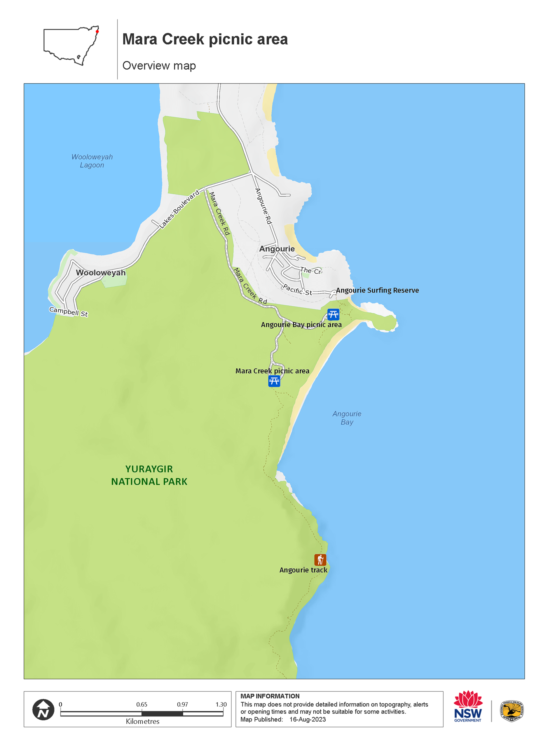
Mara Creek picnic area is located in a secluded section of the park, just inland from the coast. Even when the beach crowds flock to the area over summer holidays, this area remains a quiet section of Yuraygir.
Mara Creek picnic area is also the starting point for Angourie walking track, which takes you along the coast to Shelley Headland. Interpretive signs on this walking track offer more information about the area’s natural and cultural heritage. Enjoy a picnic before or after your hike.
Map
Map legend

Local alerts
For the latest updates on fires, closures and other alerts in this area, see https://www.nationalparks.nsw.gov.au/things-to-do/picnic-areas/mara-creek-picnic-area/local-alerts
General enquiries
- National Parks Contact Centre
- 7am to 7pm daily
- 1300 072 757 (13000 PARKS) for the cost of a local call within Australia excluding mobiles
- parks.info@environment.nsw.gov.au
Park info
- in Yuraygir National Park in the North Coast region
Yuraygir National Park is always open but may have to close at times due to poor weather or fire danger.
-
Park entry fees:
$8 per vehicle per day.
Buy annual pass.
Visitor info
All the practical information you need to know about the Mara Creek picnic area.
Getting there and parking
Mara Creek picnic area is in the northern section of Yuraygir National Park. To get there:
- Turn off Pacific Highway north of Maclean and follow Yamba Road in an easterly direction for 12km
- Turn right onto Angourie Road and follow for 4km, then turn right onto Lakes Boulevard.
- After 400m on Lakes Boulevard, turn left into Yuraygir National Park and follow that road for 1km.
- Turn right for Mara Creek picnic area
Road quality
- Unsealed roads
Vehicle access
- 2WD vehicles
Weather restrictions
- All weather
Parking
There's parking along gravel Mara Creek Road.
Weather, temperature and rainfall
Summer temperature
Average
20°C and 26°C
Highest recorded
42.5°C
Winter temperature
Average
9°C and 20°C
Lowest recorded
2.7°C
Rainfall
Wettest month
March
Driest month
September
The area’s highest recorded rainfall in one day
300mm
Facilities
Amenities
Toilets
There are accessible and ambulant flush toilets at the picnic area.
- Flush toilets
Picnic tables
Step-free access
The picnic area is mostly flat and step-free, with hard-packed ground, concrete and fibre-reinforced polymer mesh pathways.
- Step-free outdoor pathways
Maps and downloads
Accessibility
Disability access level - medium
Mara Creek picnic area is mostly flat and step-free, with the following accessible facilities:
- Accessible and ambulant toilets
- Concrete, hard-packed ground and fibre-reinforced polymer mesh pathways.
There are some parts of the picnic area where people with reduced mobility may need assistance:
- There are places where the ground slopes slightly with a maximum gradient of 1:14.
- The parking area is on the side of Mara Creek Road, which is unsealed gravel
Permitted
You're encouraged to bring gas or fuel stoves, especially in summer during the fire season.
Fishing
A current NSW recreational fishing licence is required when fishing in all waters.
Prohibited
Pets
Pets and domestic animals (other than certified assistance animals) are not permitted. Find out which regional parks allow dog walking and see the pets in parks policy for more information.
Smoking
NSW national parks are no smoking areas.
Learn more
Mara Creek picnic area is in Yuraygir National Park. Here are just some of the reasons why this park is special:
A watery wonderland

The park not only boasts a superb coastline but also features rivers, lakes and estuaries, so swimmers and snorkelers are spoilt for choice. Remember your fishing rod - the waters off the park are excellent for jewfish and groper, and Sandon River is among the state's most popular fishing spots. If surfing is your thing, you can't beat the legendary Angourie Surfing Reserve - it hosts what's arguably Australia's best right-hand point break. Yuraygir is also a paddler's paradise, its sheltered waterways provide the ideal setting for canoeing, kayaking and boating.
- Angourie Bay picnic area After surfing or swimming at the Clarence Coast’s famous Angourie Headland, stop off at the scenic Angourie Bay picnic area for a tasty picnic lunch with the family.
- Wooli to Red Rock walking track Wooli to Red Rock walking track, part of Yuraygir coastal walk, is a moderate hiking route with river crossings, scenic coastal views and great opportunities for birdwatching.
Important landscapes

When you visit Yuraygir, you're entering one of the most diverse bioregions in Australia. Wander past age-old coastal landforms, littoral rainforest, eucalypt forest, woodland and wetlands - much of which simply wouldn't be there without the park's protection. Pay a visit to Shelley Headland to see the state's most significant remaining example of grassy clay heath.
- Angourie to Brooms Head walking track Angourie to Brooms Head walking track, part of Yuraygir coastal walk, is a hiking route offering scenic lookouts and opportunities for beach walking, birdwatching, and seasonal whale watching.
- Yuraygir coastal walk Hike the multi-day Yuraygir coastal walk on the Clarence Coast near Yamba. You’ll find loads of places for whale watching, snorkelling and swimming, with overnight stops at beach campgrounds.
- Yuraygir guided treks with Home Comforts Hiking Home Comforts Hiking offers guided treks of Yuragir coastal walk with overnight accommodation in 4 charming coastal villages. It’s a great way to explore this beautiful coastline near Yamba and Coffs Harbour.
Precious and protected

At Yuraygir, you can see some of the country’s most vulnerable native wildlife up close, such as squirrel gliders and eastern grass owls. See if you can spot a rufous bettong, a rarely-seen rabbit-sized marsupial also know as the rufous rat-kangaroo. Or even the shy Queensland blossom-bat, Australia’s smallest fruit bat. The threatened green and golden bell frog is one of the 25 amphibians within Yuraygir – likely to be found around swamps, lagoons and flood plains. Keep an eye out for coastal emus, once so prevalent and now, sadly an endangered species with fewer than 100 left in the park.
- Wilsons Headland walking track The easy Wilsons Headland walking track is ideal for whale watching along the Clarence Coast. Starting at Boorkoom campground, the hiking track offers scenic coastal views.
- Yuraygir coastal walk Hike the multi-day Yuraygir coastal walk on the Clarence Coast near Yamba. You’ll find loads of places for whale watching, snorkelling and swimming, with overnight stops at beach campgrounds.
Treasured culture

The landscape of Yuraygir National Park has been, and remains, the Country of Aboriginal groups. Generations of Yaegl and Gumbaynggirr People camped, fished and held ceremonies here and numerous areas remain of strong spiritual significance to the Aboriginal community. Take the Freshwater Walk and view the most impressive pandanus palms - this important Gumbaynggirr ceremonial plant was used to weave neckbands, dillybags and baskets.
- Brooms Head to Illaroo walking track Brooms Head to Illaroo walking track, part of Yuraygir coastal walk, is a hiking route with river crossings, beach walking, scenic coastal views and birdwatching opportunities.
Plants and animals protected in this park
Animals
-

Eastern ground parrot (Pezoporus wallicus wallicus)
The eastern ground parrot is a beautiful, ground-dwelling native bird that lives in low heathland habitat along the NSW North and South coasts and escarpments. It’s listed as a vulnerable species in NSW.
-

White-bellied sea eagle (Haliaeetus leucogaster)
White-bellied sea eagles can be easily identified by their white tail and dark grey wings. These raptors are often spotted cruising the coastal breezes throughout Australia, and make for some scenic bird watching. Powerful Australian birds of prey, they are known to mate for life, and return each year to the same nest to breed.
-

Yellow-tailed black cockatoo (Calyptorhynchus funereus)
The yellow-tailed black cockatoo is one of the largest species of parrot. With dusty-black plumage, they have a yellow tail and cheek patch. They’re easily spotted while bird watching, as they feed on seeds in native forests and pine plantations.
-

Emu (Dromaius novaehollandiae)
The largest of Australian birds, the emu stands up to 2m high and is the second largest bird in the world, after the ostrich. Emus live in pairs or family groups. The male emu incubates and rears the young, which will stay with the adult emus for up to 2 years.
-

Brown-striped frog (Lymnastes peronii)
One of the most common frogs found in Australia, the ground-dwelling brown-striped frog lives in ponds, dams and swamps along the east coast. Also known as the striped marsh frog, this amphibian grows to 6.5cm across and has a distinctive ‘tok’ call that can be heard all year round.
-

Australian pelican (Pelecanus conspicillatus)
The curious pelican is Australia’s largest flying bird and has the longest bill of any bird in the world. These Australian birds are found throughout Australian waterways and the pelican uses its throat pouch to trawl for fish. Pelicans breed all year round, congregating in large colonies on secluded beaches and islands.
-

Green and golden bell frog (Litoria aurea)
The green and golden bell frog is an endangered Australian frog. Once common on the NSW coast and tablelands, populations have plummeted around 90 percent.
Plants
-

Grass tree (Xanthorrea spp.)
An iconic part of the Australian landscape, the grass tree is widespread across eastern NSW. These Australian native plants have a thick fire-blackened trunk and long spiked leaves. They are found in heath and open forests across eastern NSW. The grass tree grows 1-5m in height and produces striking white-flowered spikes which grow up to 1m long.