Fourth Crossing picnic area
Mullion Range State Conservation Area
Overview
Fourth Crossing picnic area next to Summer Hill Creek, near Orange, is a great base for exploring gold mining history on walking tracks, swimming or trout fishing.
- Type
- Picnic areas
- Accessibility
- Easy
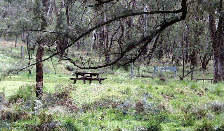
Enjoy lunch or a snack at this quiet, tranquil picnic area on Ophir Road by Summer Hill Creek. There are picnic tables, accessible toilets and signs telling you about the reserve.
Spend more time at this peaceful place by swimming in the creek or trying your luck at fishing. If you’re a nature lover, look for birds in the trees, listen to the babbling of the creek and smell the fragrant wattles in spring.
Historic Water Race walking track starts here if you want to stretch your legs. The loop walk follows a water race constructed by miners during the gold rush to transfer water from the creek to mining areas. Take care though. The return route is on an undefined trail by the creek, so it can get flooded at times.
Nearby
-

Historic Water Race walking track
Historic Water Race walking track, near Orange, is a medium-difficulty walk offering birdwatching and gold mining history as well as swimming and fishing along Summer Hill Creek.
Map
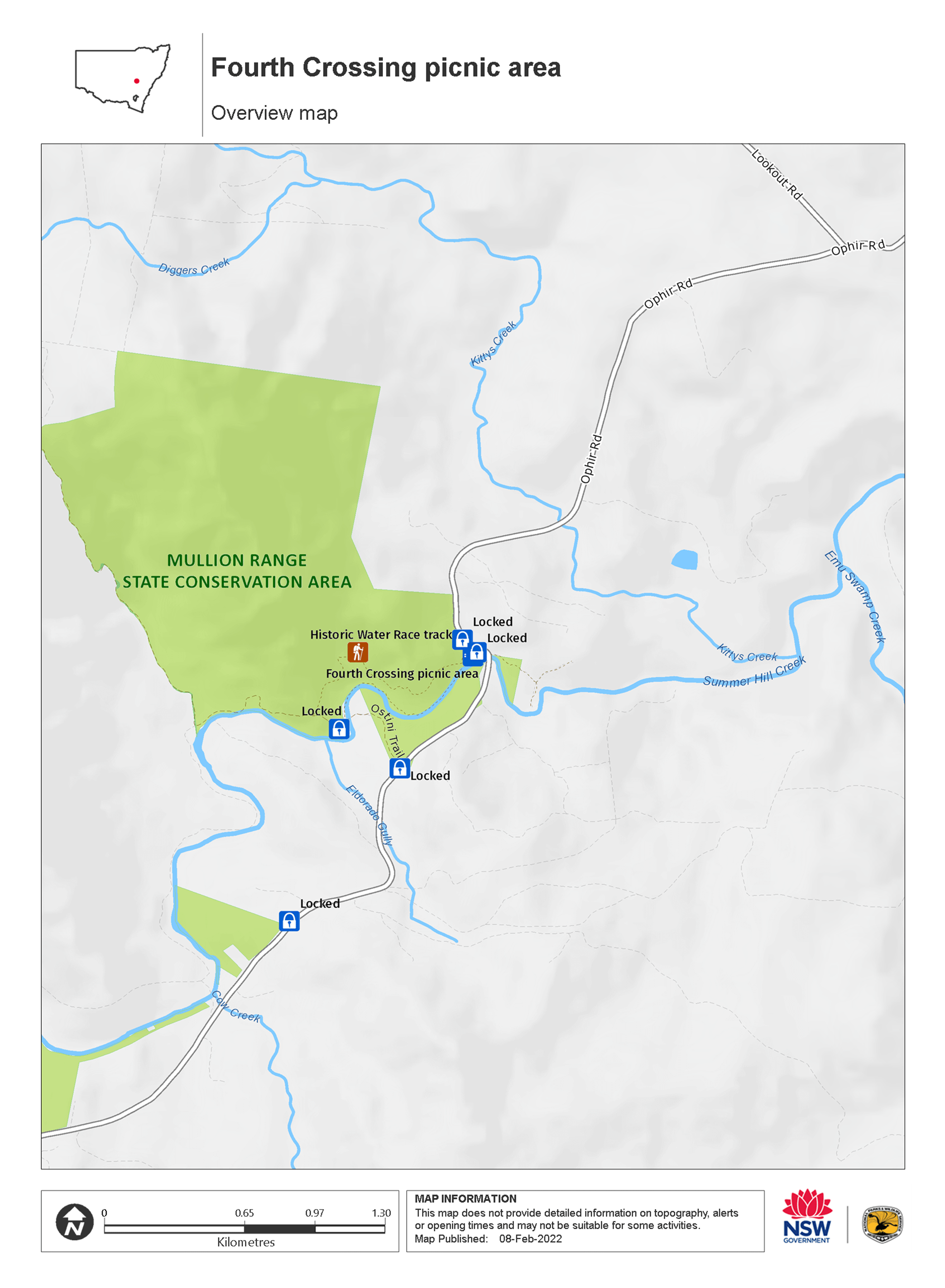
Map legend

Local alerts
For the latest updates on fires, closures and other alerts in this area, see https://www.nationalparks.nsw.gov.au/things-to-do/picnic-areas/fourth-crossing-picnic-area/local-alerts
General enquiries
- National Parks Contact Centre
- 7am to 7pm daily
- 1300 072 757 (13000 PARKS) for the cost of a local call within Australia excluding mobiles
- parks.info@environment.nsw.gov.au
Park info
- in Mullion Range State Conservation Area in the Country NSW region
Mullion Range State Conservation Area is always open but may have to close at times due to poor weather or fire danger.
Visitor info
All the practical information you need to know about the Fourth Crossing picnic area.
Getting there and parking
Fourth Crossing picnic area is in the Mullion Range State Conservation Area. To get there, travel north-east from Orange along (sealed) Ophir Road 19km to the picnic area.
Road quality
- Sealed roads
Vehicle access
- 2WD vehicles
Weather restrictions
- All weather
Parking
Parking is available in a gravel carpark at Fourth Crossing picnic area.
Best times to visit
There are lots of great things waiting for you at Mullion Range State Conservation Area. Here are some of the highlights.
Autumn
The cooler months are a great time for enjoying bushwalks, birdwatching and 4WD touring in the area.
Spring
Relax and dine al fresco surrounded by blooming wildflowers at Fourth Crossing picnic area.
Summer
Cool off with a splash in the creek or go trout fishing when the weather gets steamy.
Winter
The Falls Water Falls is particularly striking when there are high levels of water in Summer Hill Creek following heavy rainfall.
Weather, temperature and rainfall
Summer temperature
Average
12°C and 28°C
Highest recorded
38.3°C
Winter temperature
Average
2°C and 13°C
Lowest recorded
-5.6°C
Rainfall
Wettest month
August
Driest month
April
The area’s highest recorded rainfall in one day
98.6mm
Facilities
Toilets
There are accessible composting toilets next to the carpark that you can reach along a short pathway.
- Non-flush toilets
Picnic tables
Carpark
Step-free access
The picnic area is mostly flat and step-free, with some slightly sloping ground.
Aside from the short pathway to the toilets, there are no other paths - you'll need to cross over grass, hard-packed ground and gravel to reach the other facilities.
Maps and downloads
Accessibility
Disability access level - easy
Fourth Crossing picnic area is mostly flat and step-free, with some areas that slope slightly. You'll need to cross over grass, gravel and hard-packed ground to get to the picnic tables.
There's an accessible composting toilet set along a short pathway. People with reduced mobility may need assistance on the access ramp due to its slope.
Permitted
Fishing
A current NSW recreational fishing licence is required when fishing in all waters.
Prohibited
Camp fires and solid fuel burners
Campfires are prohibited in this park.
Pets
Pets and domestic animals (other than certified assistance animals) are not permitted. Find out which regional parks allow dog walking and see the pets in parks policy for more information.
Smoking
NSW national parks are no smoking areas.
Learn more
Fourth Crossing picnic area is in Mullion Range State Conservation Area. Here are just some of the reasons why this park is special:
Striking scenic water landscapes

A prominent feature of the landscape of this reserve is the mix of rocky outcrops and the waters of Summer Hill Creek.
Good as gold

Explore the past by discovering fascinating remnants of the Mullion's gold mining boom. From 1860 to 1920, intrepid gold mining pioneers created mining sites and a water race that was built by hand to transport water from the creek to the mining areas.
- Historic Water Race walking track Historic Water Race walking track, near Orange, is a medium-difficulty walk offering birdwatching and gold mining history as well as swimming and fishing along Summer Hill Creek.
- The Falls The Falls, near Summer Hill Creek in Mullion Range State Conservation Area, provide a scenic vista and popular swimming location.
Unique plant and birdlife

You may spot interesting wildlife here, like eastern grey kangaroos, red-necked wallabies and wallaroos bounding through open fields. Gliders scurry among the treetops and platypus paddle their way along the creek. Large swathes of vegetation on the flatter areas of Mullion Range State Conservation Area have remained relatively undisturbed, thanks to the area's mining past. This means you can see a number of plant species and communities here that are rarely found elsewhere in central western NSW, including inland scribby gum, red stringybark and river oak. Mullion Range also provides habitat for many unique and interesting species of woodland birds, such as native parrots, including eastern rosellas and crimson rosellas, superb parrots in the springtime, and owls.
- Fourth Crossing picnic area Fourth Crossing picnic area next to Summer Hill Creek, near Orange, is a great base for exploring gold mining history on walking tracks, swimming or trout fishing.
- The Falls The Falls, near Summer Hill Creek in Mullion Range State Conservation Area, provide a scenic vista and popular swimming location.