Greater Blue Mountains drive – Wollondilly trail
Bargo State Conservation Area
Overview
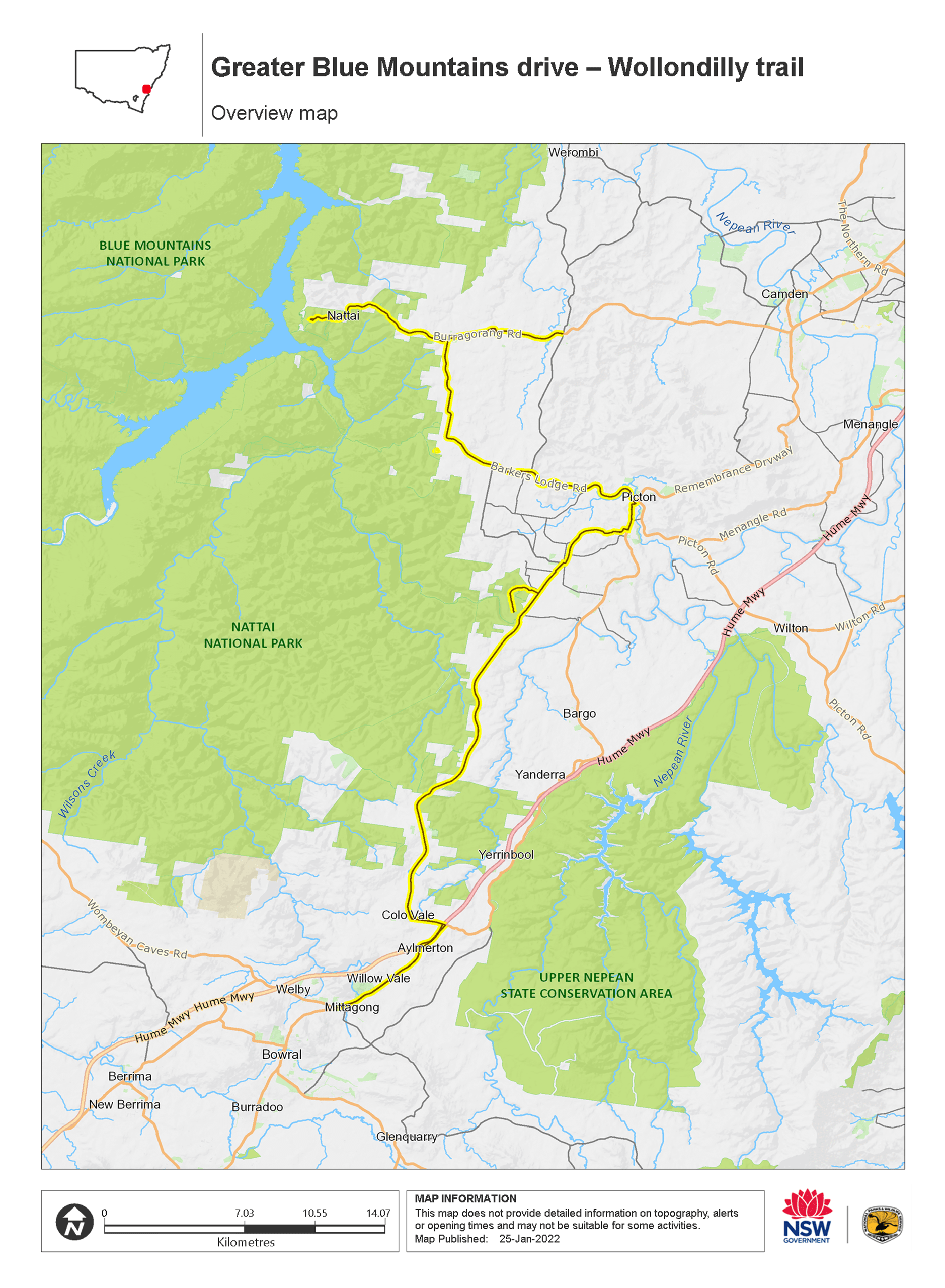
Wollondilly trail, part of the Greater Blue Mountains drive, takes in scenic views of Mittagong Nattai, Thirlmere Lakes and Bargo State Recreation Area, Camden and Picton.
- Distance
- 70km one-way
- Time suggested
- 1hr 30min
Part of the Greater Blue Mountains drive, Wollondilly trail is a great way to see idyllic parts of greater Sydney from the comfort of your car. Pack a picnic lunch before you head off on this scenic mountain drive because you’ll find plenty of picturesque settings to stop and eat at.
This rural bushland circuit off the Hume Highway from Mittagong takes about an hour and a half all-up and tours past Thirlmere Lakes, Nattai National Park, and the Bargo State Recreation Area.
Stop and stretch your legs at Wombeyan Caves, where you can picnic on the spacious grounds or take a self-guided cave tour. Along the way, you can also visit the Train Heritage Works Museum in Thirlmere, with its amazing collection of locomotives. Be sure to stop in Camden, not far from Campbelltown, where rural life gets a glamorous twist. You can then stop off in charming, historic Picton for a coffee and a browse of the local galleries.
Map

Map legend

Local alerts
For the latest updates on fires, closures and other alerts in this area, see https://www.nationalparks.nsw.gov.au/things-to-do/driving-routes/greater-blue-mountains-drive-wollondilly-trail/local-alerts
General enquiries
- National Parks Contact Centre
- 7am to 7pm daily
- 1300 072 757 (13000 PARKS) for the cost of a local call within Australia excluding mobiles
- parks.info@environment.nsw.gov.au
Park info
- in Bargo State Conservation Area in the Sydney and surrounds and Country NSW regions
Bargo State Conservation Area is always open but may be closed at times due to poor weather or fire danger.
Visitor info
All the practical information you need to know about Greater Blue Mountains drive – Wollondilly trail.
Getting there and parking
Get driving directions
Wollondilly trail is part of Greater Blue Mountains drive. To get there:
- Join Greater Blue Mountains drive in Nattai National Park and travel east along Burragorang Road. Continue all the way to The Oaks, or turn right onto Barkers Lodge Road and head south.
- Travelling along Barkers Lodge Road along the eastern side of Nattai National Park takes you to Picton.
- Exit Picton via Thirlmere Way which takes you to Thirlmere Lakes National Park and Bargo State Recreation Area.
- Travel over the Hume Highway and follow signs to Mittagong, where this part of the Greater Blue Mountains drive ends.
Best times to visit
There are lots of great things waiting for you in Nattai National Park. Here are some of the highlights.
Autumn
Mild weather and misty mornings; a great time to explore some of the longer hikes in the park, including Starlight's trail and Couridjah Corridor walk.
Spring
Enjoy the incredible array of wildflowers that cover the ground in the rainforests and the mild weather.
Summer
Swim or canoe in the lakes and rivers.
Weather, temperature and rainfall
Summer temperature
Average
22°C and 27°C
Highest recorded
42.8°C
Winter temperature
Average
12°C and 15°C
Lowest recorded
-10° C
Rainfall
Wettest month
March
Driest month
September
The area’s highest recorded rainfall in one day
247.4mm
Maps and downloads
Prohibited
Pets
Pets and domestic animals (other than certified assistance animals) are not permitted. Find out which regional parks allow dog walking and see the pets in parks policy for more information.
If you're travelling through a national park or reserve on a public road you can have pets inside your vehicle. However, you must keep them inside your vehicle while driving through national parks or reserves. You must also comply with any conditions in the park’s plan of management, and you cannot stop to visit the park or use park facilities (unless for safety reasons, or to use publicly accessible toilets).
Smoking
NSW national parks are no smoking areas.
Learn more
Greater Blue Mountains drive – Wollondilly trail is in Bargo State Conservation Area. Here are just some of the reasons why this park is special:
Aboriginal connection

The Bargo reserve system falls within the area of Dharawal Land Council. Dharawal People lived mainly on fruits, vegetables, fish and shellfish. The women collected plant foods and were known for their excellent canoeing and fishing skills. Men speared fish and hunted land mammals. The reserve contains numerous reminders of these activities, with Aboriginal sites including axe grinding grooves, wells, engravings and surface artefact sites.
Bargo Brush

In about 1798, Europeans discovered the Bargo area. Attempts were made to settle the land and run cattle. However, nobody who was granted land outside the colony of Sydney chose to take up the grant in Bargo. The land was considered of poor quality for grazing and people settled further south. Bargo became a feared place and dangerous to travel through. The road built to pass through 'Bargo Brush' became hazardous; the forest, and its thick understorey, was a great place for bushrangers to hide. In 1863, even the established railway line at Picton bypassed Bargo.
Green communities

Bargo is dominated by dry sclerophyll forest that is typical to NSW, but the reserve also houses pockets of warm-temperate rainforest. Eleven rare plant species grow within these rainforest areas, including hairy and Mittagong geebung, narrow-leaved mallee ash eucalyptus and native cranberry. Given the more barren nature of the soil in this area, it stands to reason that warm-temperate rainforest replaces subtropical rainforest on poorer soils at higher altitudes in NSW.
Wildlife-watch

Enjoy the company of native Australian animals in this reserve, such as eastern grey kangaroos, koalas and platypus. There are also vulnerable tiger quolls and long-nosed potoroos cohabiting with 19 reptile species and nine frog species. The majority of the Bargo local wildlife can be easily spotted early morning or late afternoon. Bargo is also ideal for birdwatching, as there are over 160 species of birds which have been found to nest or feed in the area, including glossy black cockatoos.

