Long Gully campground
Budawang National Park

Overview
Free river camping for experienced and well-equipped travellers, Long Gully campground offers drop toilets and picnic tables, with nearby day walks for fit hikers.
| Number of campsites | 7 |
|---|---|
| Camping type | Tent, Camper trailer site, Camping beside my vehicle |
| Facilities | Picnic tables, carpark, toilets |
| What to bring | Drinking water, cooking water |
| Price | There are no camping fees at this campground but a $6 booking fee applies. |
| Bookings | Book up to 12 people or 2 sites online. |
| Group bookings | School groups and Park Eco Pass holders can make a group booking enquiry. |
| Please note |
|
Long Gully campground, like Budawang in general, is one for experienced travellers. Located on a grassy flat beside Yadboro River, surrounded by blackbutt trees and rising steeply on the northern side, this is a place you come to get away from everything. Facilities are minimal – pit toilets and picnic tables, with no marked sites – but the sort of person who comes here is self-sufficient and hardy. Plus, the scenery is spectacular.
Bring the tent, firewood, and enough food to last (water can be collected from the river and boiled), then settle down in scenic solitude. The remoteness of Long Gully means your closest neighbours are likely to be goannas and wallabies, though there is an adjacent picnic area. Avid bushwalkers will want to pack their hiking boots and compass as well for an exhilarating walk in the Budawang backcountry. The arduous trek to the Castle also begins from here, suitable for well-equipped adventurers only.
Wherever you end up, return to a refreshing splash in Yadboro, though better swimming opportunities can be found in nearby Clyde River. Don’t forget your towel.
Map
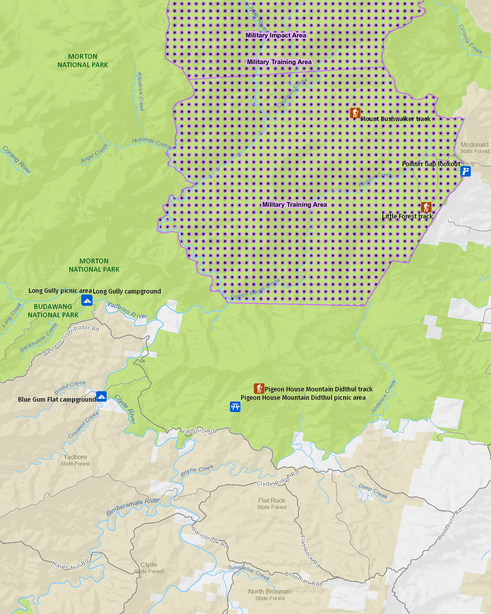
Map legend

Local alerts
For the latest updates on fires, closures and other alerts in this area, see https://www.nationalparks.nsw.gov.au/camping-and-accommodation/campgrounds/long-gully-campground/local-alerts
Bookings
- National Parks Contact Centre
- 7am to 7pm daily
- 1300 072 757 (13000 PARKS) for the cost of a local call within Australia excluding mobiles
- parks.info@environment.nsw.gov.au
Operated by
- Ulladulla office
- Monday to Friday, 9am to 4pm.
- 02 4454 9500
- npws.shoalhaven@environment.nsw.gov.au
- Lot 9 Blackburn Industrial Estate, 6 Coller Road Ulladulla NSW 2539
Park info
- in Budawang National Park in the South Coast and Country NSW regions
Budawang National Park is always open but may have to close at times due to poor weather or fire danger.
Visitor info
All the practical information you need to know about Long Gully campground.
Maps and downloads
Learn more
Long Gully campground is in Budawang National Park. Here are just some of the reasons why this park is special:
A natural haven

Budawang National Park supports a wide variety of trees and plants, so budding naturalists will find much of interest here. The eastern slopes of the range contain tall eucalypt forests, temperate rainforest, and several threatened species. There are Budawang ash and pinkwoods as well.
- Long Gully picnic area Long Gully picnic area is a comfortable spot to settle down for the day beside scenic Yadboro River, with nearby swimming and day walks for the experienced hiker.
- Mount Budawang trail A challenging yet rewarding walk, cutting through several environments; from grassy woodland to montane forest, and finishing at the summit for scenic views.
Old stock routes

Once European settlers arrived, early exploration of the area concentrated on finding routes across the rugged escarpment country to link the tablelands and coast. Many of the ancient Aboriginal pathways became an important part of the early bridle trail network used for movement of stock. One of these was Wog Wog track, which was used to move cattle from Braidwood to the coast.
Rare plant refuge

High up, on the summits of Mount Budawang and Currockbilly Mountain, you'll find the last refuge of the critically endangered Budawang wallaby grass. This rare plant doesn't grow anywhere else in the world, and has been declared an Asset of Intergenerational Significance, giving it extra legal protections. With such a small population remaining in the wild, this threatened grass species is at risk from catastrophic fire events and, in particular, human disturbance. Help us secure this native species for future generations by cleaning your walking shoes before you visit to avoid introducing invasive weeds and pathogens like deadly Phytophthora cinnamomi, and stay on tracks to avoid trampling seedlings, damaging exposed roots and fragile soils.
Volcanic foundations

Southern Budawang Range is formed on Devonian sediments that were uplifted to form the Budawang Synclinorium. Volcanic rock on the slopes slowly transforms into fertile soil that supports the varied ecosystems of tall moist forest and rainforest. The altitude range in the park is more than 800 metres, though two peaks in the park - Mount Budawang and Currockbilly Mountain - rise to over 1,100m above sea level.
- Mount Budawang trail A challenging yet rewarding walk, cutting through several environments; from grassy woodland to montane forest, and finishing at the summit for scenic views.