Boundary Falls campground and picnic area
Gibraltar Range National Park
Overview
This campsite just off the main road between Glen Innes and Grafton offers great walks, picnic spots, barbecues, and a stunning natural waterfall right nearby.
| Number of campsites | 8 |
|---|---|
| Camping type | Tent, Camper trailer site, Caravan site, Camping beside my vehicle |
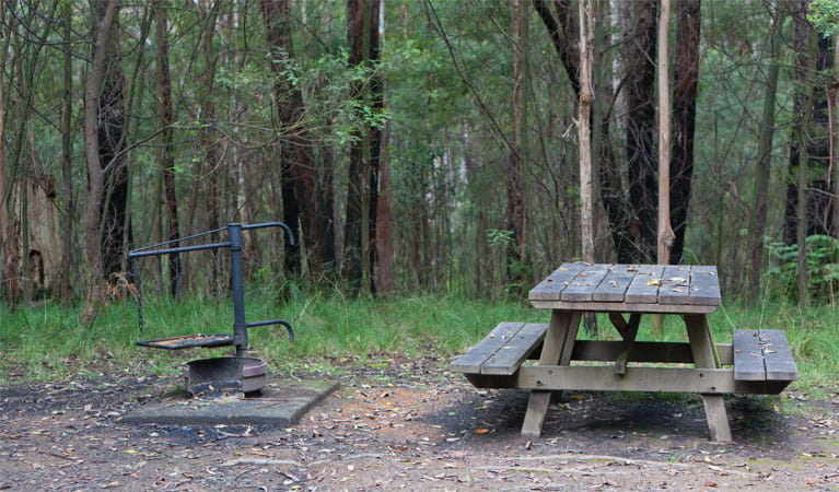
| Facilities | Picnic tables, barbecue facilities, toilets |
| Entry fees | Park entry fees apply |
| Bookings | Book up to 12 people or 2 sites online. |
| Group bookings | School groups and Park Eco Pass holders can make a group booking enquiry. |
| Please note |
|
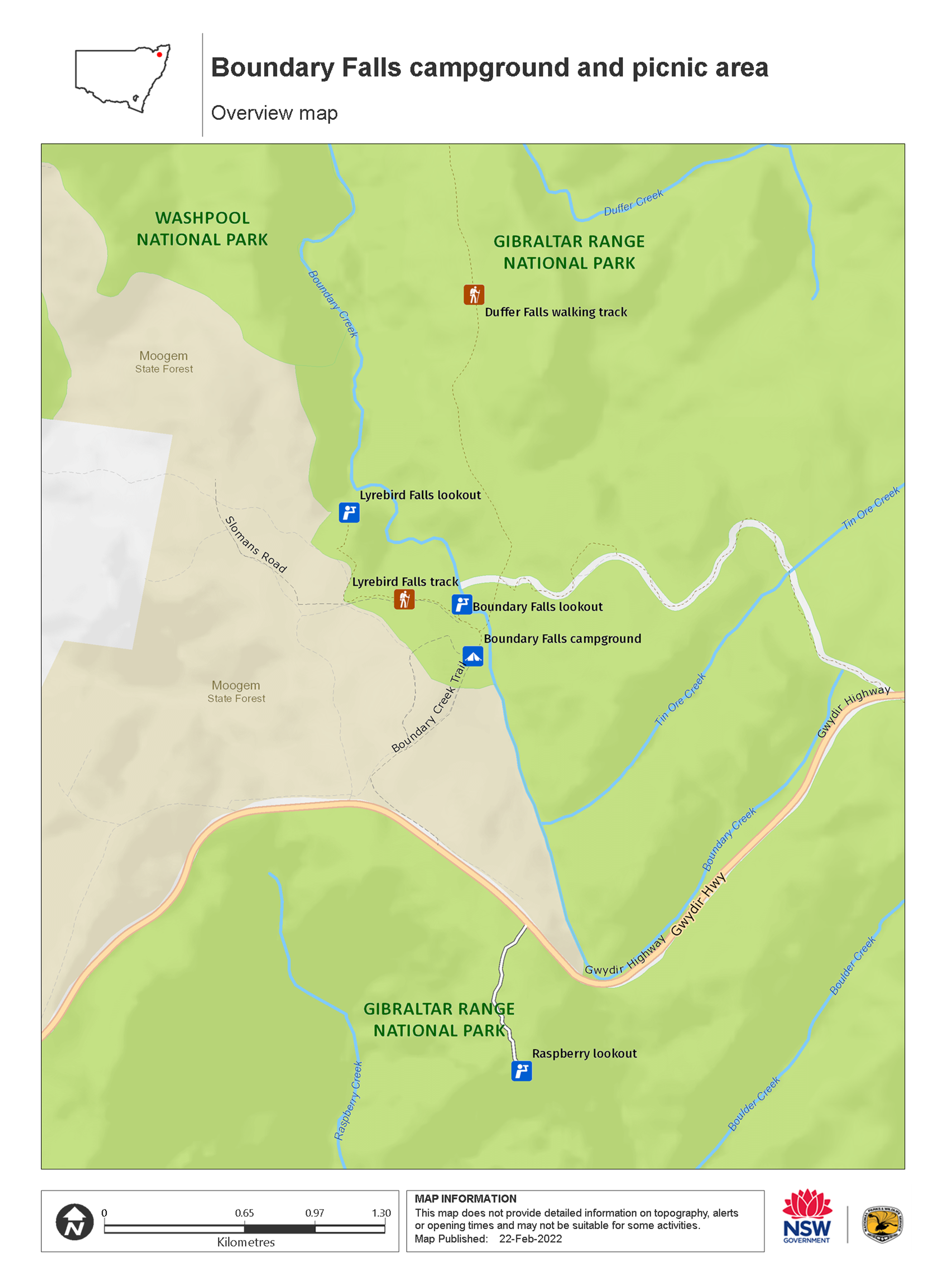
Just a short drive off the main road between Glen Innes and Grafton, the Boundary Falls campground and picnic area is tucked away in scenic dry forest on the site of an old sawmill. With everything you need, this is a great spot to unfurl the tent and set up camp for a few days.
Take advantage of the open spaces with some light sport, or pass an afternoon in the shade of eucalypts with the tempting aroma of barbecue in the air. With spectacular waterfalls nearby, it’s a good idea to pack the camera.
Adventurous travellers might want to tackle the walk to Duffer Creek or the more challenging, multi-day Gibraltar-Washpool World Heritage walk. Keep an eye out for signs in the area, explaining local history, wildlife and flowers, like the state flower, the red waratah, which bloom here throughout the year.
Also see
-
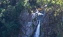
Lyrebird Falls lookout
Lyrebird Falls lookout is in Gibraltar Range National Park along Lyrebird Falls walking track. Visit this scenic spot to see beautiful little waterfalls and enjoy views over Boundary Creek.
-
Lyrebird Falls walking track
Lyrebird Falls walking track, in Gibraltar Range National Park, is a short walk from Boundary Falls picnic area though eucalypt forest to a scenic waterfall.
-
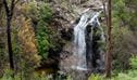
Boundary Falls lookout
Boundary Falls lookout is in Gibraltar Range National Park, near Boundary Falls campground and picnic area. It’s a great spot to relax or enjoy a cool dip.
Map
Map legend

Local alerts
For the latest updates on fires, closures and other alerts in this area, see https://www.nationalparks.nsw.gov.au/camping-and-accommodation/campgrounds/boundary-falls-campground-and-picnic-area/local-alerts
Bookings
- National Parks Contact Centre
- 7am to 7pm daily
- 1300 072 757 (13000 PARKS) for the cost of a local call within Australia excluding mobiles
- parks.info@environment.nsw.gov.au
Operated by
- Glen Innes office
- Monday to Friday, 8.30am to 4.30pm.
- 02 6739 0700
- npws.ntab@environment.nsw.gov.au
- 68 Church Street, Glen Innes NSW 2370
Park info
- in Gibraltar Range National Park in the North Coast and Country NSW regions
Gibraltar Range National Park is always open but may have to close at times due to poor weather, road damage, or high fire danger.
-
Park entry fees:
$8 per vehicle per day. The park uses a self-registration fee collection system. Please bring the correct change and display your receipt.
Buy annual pass.
Visitor info
All the practical information you need to know about the Boundary Falls campground and picnic area.
Getting there and parking
Boundary Falls campground and picnic area is in Gibraltar Range National Park. To get there:
- From Glen Innes, drive 63km east towards Grafton along the Gwydir Highway.
- From Grafton, drive 97km west towards Glen Innes along the Gwydir Highway.
- The campground and picnic area is located a short distance off the main road and is well sign-posted
Road quality
- Unsealed roads
Vehicle access
- 2WD vehicles
Weather restrictions
- All weather
Parking
Parking is available in a gravel carpark at the northern end of the picnic area and campground. You can also park directly at your campsite if you're staying at the campground.
Best times to visit
There are lots of great things waiting for you in Gibraltar Range National Park. Here are some of the highlights.
Spring
The most popular time of the year to visit, spring sees the park erupt into a vibrant display of wildflowers, including the Gibraltar waratah.
Summer
Take in an early morning bushwalk before the day heats up, then cool down in one of the many waterways, like the Little Dandahra Creek.
Winter
It can be below freezing at night, but the daytime temperatures make this the best time of the year to take in some of the longer treks like the Gibraltar-Washpool World Heritage walk.
Weather, temperature and rainfall
Summer temperature
Average
13°C and 24.1°C
Highest recorded
35°C
Winter temperature
Average
1°C and 13.2°C
Lowest recorded
-8.9°C
Rainfall
Wettest month
January
Driest month
August
The area’s highest recorded rainfall in one day
258.4mm
Facilities
Tank water is available at this campground; you’ll need to treat or boil it before drinking.
Toilets
This campground has a single drop toilet.
- Non-flush toilets
Picnic tables
Barbecue facilities
- Wood barbecues (firewood supplied)
Step-free access
The campground and picnic area are flat and step-free, with a mixture of hard-packed ground and gravel pathways.
- Step-free outdoor pathways
Maps and downloads
Accessibility
Disability access level - medium
Boundary Falls campground and picnic area is mostly flat and step-free. There are formal and informal gravel and hard-packed ground pathways.
The single drop toilet is not accessible or ambulant.
Permitted
Gathering firewood
There may be a supply of firewood, however it’s a good idea to bring your own supply.
Prohibited
Pets
Pets and domestic animals (other than certified assistance animals) are not permitted. Find out which regional parks allow dog walking and see the pets in parks policy for more information.
Smoking
NSW national parks are no smoking areas.
Learn more
Boundary Falls campground and picnic area is in Gibraltar Range National Park. Here are just some of the reasons why this park is special:
Lands of plenty

The European heritage of the park may be shorter, but look around and you'll find its traces clearly etched in the natural environment. Living around the range are direct descendants of graziers, lumberers and miners who made their livings here. Bullock teams and horses once struggled through the bush and granite tors, attempting to tame a landscape that today inspires for its wild ruggedness. Evidence of their work can be glimpsed at Mulligans campground and picnic area, where an aborted hydro-electric scheme from the 1900s is memoralised by a remaining hut and several weirs. Hikers on the wide-reaching Gibraltar-Washpool World Heritage walk might also notice relics of pre-WWII tin and gold-mining operations in the Grassy Creek area.
- Dandahra Crags walking track Dandahra Crags walking track, in Gibraltar Range National Park, is a hiking route with scenic views and birdwatching opportunities.
- Gibraltar-Washpool World Heritage walk Keep an eye out for birds and wildflowers on the 45km Gibraltar-Washpool World Heritage walk through eucalypt forests, rainforests, wetlands and granite tors in the rugged Northern Tablelands.
World Heritage Area

Part of the Gondwana Rainforests Reserves of Australia, Gibraltar Range is listed on the World Heritage register for rainforest plants that have existed since Australia was part of the Gondwana super-continent. Gibraltar Range National Park is home to several threatened species of animal: the endangered giant barred frog, which can grow to the size of a small adult's hand; and glossy black cockatoos, under threat from a loss of breeding habitat. Feeding locations are very important to the continuing survival of the cockatoo.
- Dandahra Falls walking track Suitable for fit and experienced bushwalkers only, Dandahra Falls walking track in Gibraltar Range National Park offers impressive waterfall views in stunning World Heritage surrounds.
- Duffer Falls walking track Within easy reach of Glen Innes or Grafton and ideal for a day trip, Duffer Falls walking track offers waterfall views in the beautiful forest setting of Gibraltar Range National Park.
- Gibraltar-Washpool World Heritage walk Keep an eye out for birds and wildflowers on the 45km Gibraltar-Washpool World Heritage walk through eucalypt forests, rainforests, wetlands and granite tors in the rugged Northern Tablelands.
- Junction Spur walking track For experienced bushwalkers only, Junction Spur walking track in Gibraltar Range National Park will suit adventure seekers who want to get off the beaten track and explore the tablelands.
- The Needles walking track The Needles walking track offers jaw-dropping views of granite rock formations in Gibraltar Range National Park, near Glen Innes. Part of the Gibraltar-Washpool World Heritage walk, it’s a great shorter walk option.
Years in the making

Long stewarded through history by Aboriginal people in the area, the Gibraltar Range continues to hold significance for contemporary descendants. The Range is rich in cultural sites and sacred places, with Aboriginal groups having moved regularly between the tablelands and coastal plains, conducting ceremonies and gathering food along the way.
- Dandahra Crags walking track Dandahra Crags walking track, in Gibraltar Range National Park, is a hiking route with scenic views and birdwatching opportunities.
Education resources (1)
Bookings
- National Parks Contact Centre
- 7am to 7pm daily
- 1300 072 757 (13000 PARKS) for the cost of a local call within Australia excluding mobiles
- parks.info@environment.nsw.gov.au
Operated by
- Glen Innes office
- Monday to Friday, 8.30am to 4.30pm.
- 02 6739 0700
- npws.ntab@environment.nsw.gov.au
- 68 Church Street, Glen Innes NSW 2370
Park info
- in Gibraltar Range National Park in the North Coast and Country NSW regions
Gibraltar Range National Park is always open but may have to close at times due to poor weather, road damage, or high fire danger.
-
Park entry fees:
$8 per vehicle per day. The park uses a self-registration fee collection system. Please bring the correct change and display your receipt.
Buy annual pass
What's nearby:
Things to do (28)
- Aboriginal culture (2)
- Birdwatching and wildlife encounters (6)
- Canoeing/paddling (2)
- Historic heritage (6)
- Horse riding (1)
- Photography (1)
- Picnics and barbecues (6)
- Road trips and car/bus tours (1)
- Sightseeing (19)
- Swimming (4)
- Walking (20)
- Waterfalls (11)
- Waterhole (1)
- Wildflowers (seasonal) (5)